
Bruce Highway (Cooroy to Curra) Section D
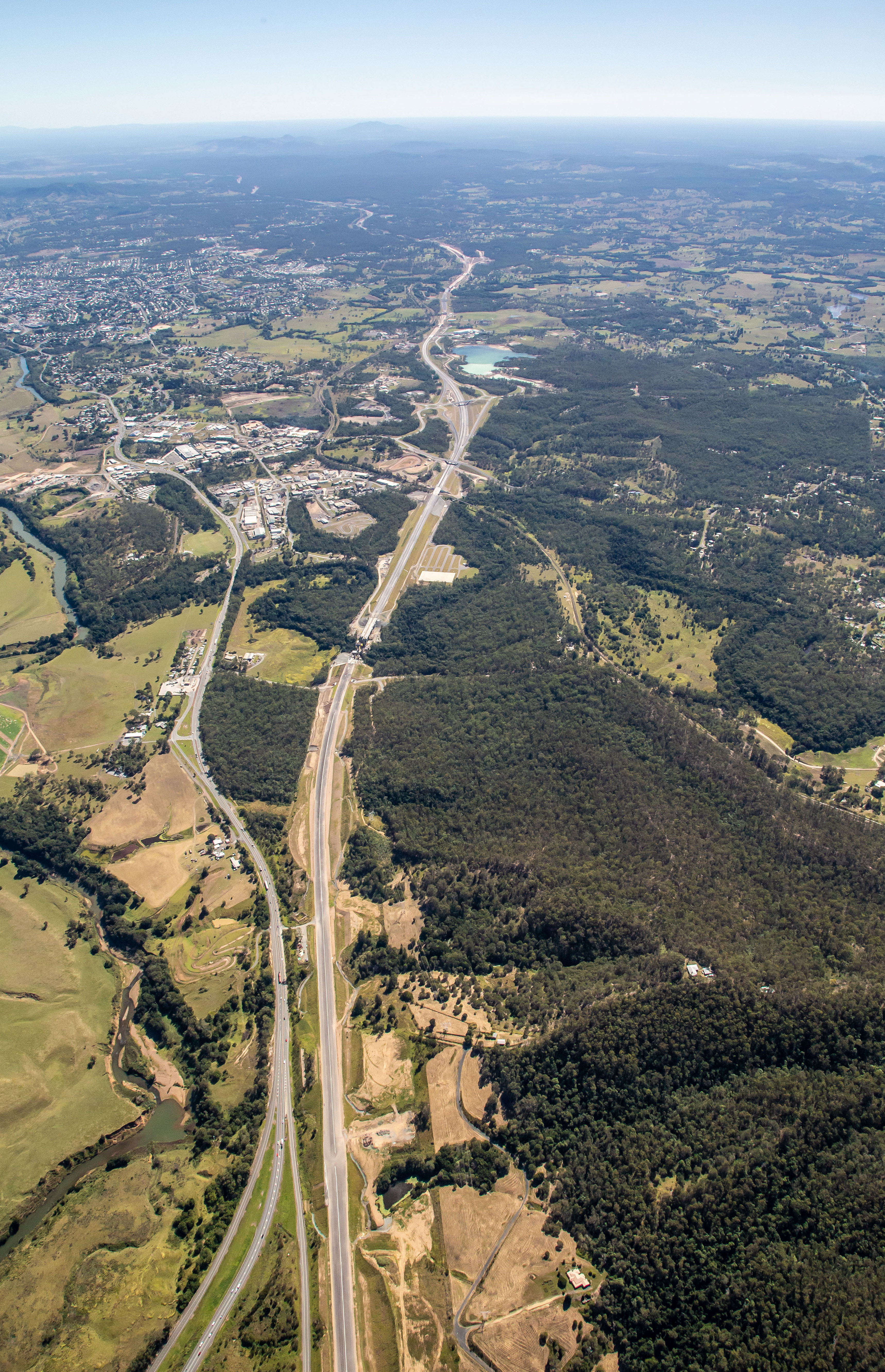
The $1 billion Section D: Woondum to Curra project is a new 26km, 4-lane divided highway between the existing Bruce Highway interchange at Woondum, south of Gympie and Curra.
The Section D (Gympie Bypass) project is being delivered in 2 construction contracts, with work underway since October 2020.
Community Open Day — register your interest
What
The Section D (Gympie Bypass) project is on track to be completed in late 2024, weather permitting.
A Community Open Day is planned for Saturday 17 August 2024 at the site of the new Flood Road interchange. To enable the community to be involved in celebrating the end of this major infrastructure project, the department needs to get an idea of attendee numbers.
Plans for the event are still being confirmed and may include:
- An option to walk the new bypass from the Flood Road interchange to the new 250m-long Six Mile Creek bridges (approximately 5km)
- Market style food vans for attendees to purchase food and beverages
- Entertainment and informative displays.
Important information: this is an event occurring prior to any traffic switching onto the new Gympie Bypass which will occur shortly after this event.
How
Please register your interest to attend this family-friendly event. The registration will stay open until 12 July 2024.
This is not a ticketed event; this registration of interest is to get an idea of attendee numbers only.
We are still in the early planning stages for this event and further details will be released at a later stage.
We will announce the full line up of activities and entertainment, along with parking and other information several weeks prior to the event.
Visualisation video of final design
Benefits
- Increases traffic flow
- Increases capacity
- Improves safety
- Improves flood immunity
- Reduces travel time
- Contributes to economy
- Contributes to regional growth
Key features
- Improve traffic flow, as the upgrade will avoid 53 intersections (including 9 signalised intersections) and 106 property accesses which contribute to current safety and congestion issues on the existing Bruce Highway
- Improve safety and capacity through the separation of long-distance traffic from local traffic. This will reduce traffic volumes on the highway travelling through Gympie, with around 50% less heavy vehicles
- Greatly reduce head-on crashes by providing a divided 4-lane highway
- Significantly improve flood immunity compared with the old highway, which has traditionally experienced frequent closures in the Gympie CBD and north and south of Gympie due to flooding
- Improve travel times by having the new highway posted at 110km/h (currently the highway is 80km/h and 60km/h through Gympie).
Funding
This project is jointly funded by the Australian and Queensland governments. Investment ID 686965
- Total investment
- $1.162 billion
- Australian Government
- $929.6 million
- Queensland Government
- $32.4 million
Current status
The Gympie Bypass is being delivered in 2 major construction contracts:- Contract 1: Woondum interchange to Sandy Creek Road (Bielby Holdings and BMD Group Join Venture)
- Contract 2: Sandy Creek Road to Curra (CPB Contractors)
There are 42 bridges at 23 locations along the Gympie Bypass. More than 6 million cubic metres of earth has been moved from cuts to fill areas. This raises the new section of highway to a level that will increase the flood immunity to withstand a one-in-100-year flood event.
Major construction has been underway since October 2020 with earthworks on both contracts now complete and all bridge structures in the final stages of finishing works.
Works still underway to complete the project include:
- Laying pavement
- Complete connections between the 2 major contracts and on the Bruce Highway north and south of Gympie
- Line marking
- Install lighting and intelligent transport systems
- Signage along the entire corridor.
Preparations are now being undertaken to complete the project and celebrate this major milestone. Register your interest to attend the Community Open Day.
Woondum interchange looking north (existing Bruce Highway on left - new Bruce Highway under construction on right)
Six Mile Creek bridges

Flood Road interchange

Deep Creek bridges
Looking south through the Curra State Forest from Bradys Road bridge

Curra interchange bridge open to local Ashfords Road traffic

New Flood Road interchange
An all-movements interchange at Flood Road will cater for locals and industry, enabling heavy vehicles to access commercial and industrial areas east and west of the new highway.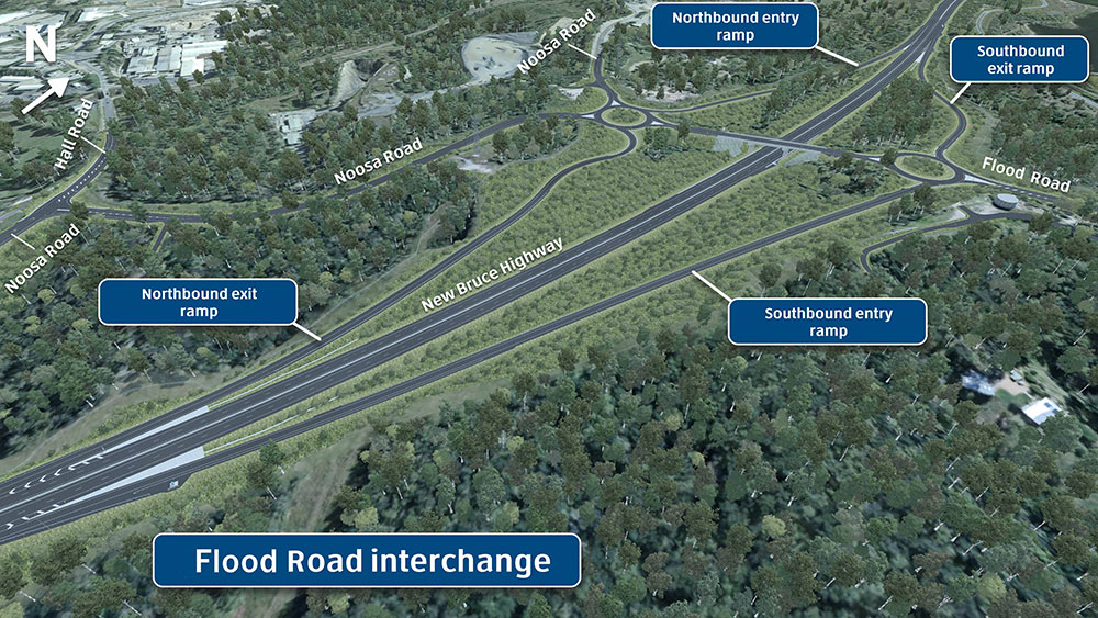
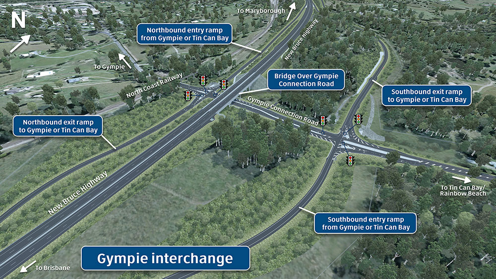
New Gympie interchange
An all movements interchange will be constructed at Gympie Connection Road to cater for commuters travelling to Gympie or the Cooloola Coast from the new highway. Traffic signals will be located at each exit ramp and entry ramp intersection with Gympie Connection Road to manage safe flow of traffic between the new highway and the local road network.
New Curra interchange
An all and construction conditions movements interchange will be constructed just north of Curra to connect the new 4-lane highway with the existing 2-lane Bruce Highway. The interchange will be to the north of the existing Harvey Siding Road and Bruce Highway intersection. Connections will be made back to Harvey Siding and Ashfords roads for local traffic.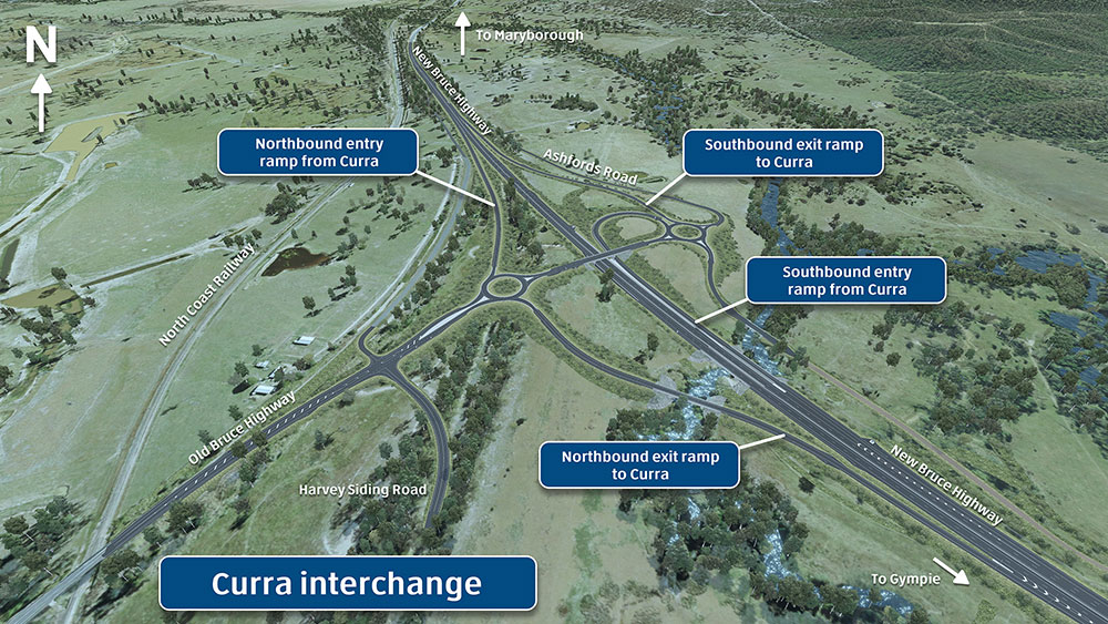
Drone video of construction of the Six Mile Creek bridge: July 2021
Bruce Highway (Cooroy to Curra) Section D—Earthworks update: September 2022
Bruce Highway (Cooroy to Curra) Section D-Time lapse of Flood Road interchange construction: 27 March 2023
Environment
Compliance reports
Environment Protection and Biosecurity Conservation Act 1999 (EPBC Act) compliance reports for the Bruce Highway Cooroy to Curra (Section D: Woondum to Curra):
Compliance Report 01 (December 2021)(PDF, 566KB)
- Appendix A: EPBC Act—post approvals variation notice 01 (PDF, 5.5MB)
- Appendix B: Six Mile Creek lowland rainforest baseline survey report (PDF, 14.1MB)
- Appendix C: Mary River Catchment Coordination Committee purchase order (PDF, 308KB)
- Appendix D: Pineapple zamia translocation report (PDF, 4.4MB)
- Appendix E: Pineapple zamia propagation memo (PDF, 1.8MB)
- Appendix F: Vegetation Management Act voluntary declaration notice (PDF, 149KB)
- Appendix G: Pineapple zamia monitoring report (PDF, 4.8MB)
- Appendix H: Pest animal baseline survey report (PDF, 14.8MB)
- Appendix I: Ecosure restoration plan (PDF, 6.5MB)
- Appendix J: Pest animal monitoring program (PDF, 15.9MB)
- Appendix K: Pest animal control plan (PDF, 7.5MB)
- Appendix L: Offset Management Plan lowland rainforest (PDF, 6.8MB)
- Appendix M: Lowland rainforest offset baseline survey (PDF, 14.7MB)
- Appendix N: MNES clearing sketch (PDF, 845KB)
Compliance Report 02 (December 2022)(PDF, 662KB)
- Appendix A: Postapprovals Notice of Variation - Conditions 3 to 7 (PDF,1.97MB)
- Appendix B: Pineapple zamia translocation monitoring report year 2 (PDF, 4.63MB)
- Appendix C: Offset area habitat monitoring report year 1 (PDF, 18.5MB)
- Appendix D: Offset area Pest Animal monitoring report year 1(PDF, 4.07MB)
- Appendix E: TEC Lowland rainforest offset area monitoring report year 1 (PDF, 7.58MB)
- Appendix F: MNES clearing impact area sketch
Compliant report 03 (December 2023) (PDF, 585KB)
- Appendix A: EPBC Act post approvals variation notice 01 (PDF, 5.41MB)
- Appendix B - Pineapple zamia - Memo - Translocation Monitoring - December 2023 (PDF, 118KB)
- Appendix C: C2CD Offset Pest Animal Monitoring Report Year 2 (PDF, 6.32MB)
- Appendix D: Clearing impact area sketch (PDF, 892KB)
- Bruce Highway Cooroy to Curra (Section D: Woondum to Curra): Offset Management Plan (koala)
- Bruce Highway Cooroy to Curra (Section D: Woondum to Curra): Baseline Assessment Report - 2020
- Bruce Highway Cooroy to Curra (Section D: Woondum to Curra): lowland rainforest offset strategy
- Bruce Highway Cooroy to Curra (Section D: Woondum to Curra): notice of variation - conditions 3 and 7
- Bruce Highway Cooroy to Curra (Section D: Woondum to Curra): final decision notice September 2019
- Bruce Highway Cooroy to Curra (Section D: Woondum to Curra): EPBC Act Referral - public consultation summary
- Bruce Highway Cooroy to Curra (Section D: Woondum to Curra): preliminary documentation May 2018
- Bruce Highway Cooroy to Curra (Section D: Woondum to Curra): EPBC Act referral April 2017
- Bruce Highway Cooroy to Curra (Section D: Woondum to Curra): referral form
