
Walking networks for everyone
Action 1.11, Action Plan for Walking 2022–2024
Department/Agency: Department of Transport and Main Roads
Status: Complete
Prepare and publish inclusive mapping for key precincts to incorporate the access needs of people with disability. Work across locations including regional communities and selected Brisbane 2032 Olympic and Paralympic Games precincts.
Overview
The Department of Transport and Main Roads commissioned inclusive mapping in three areas to provide better data on the needs of people with a disability who use walking infrastructure such as footpaths and pedestrian crossings. The information provides planners with detailed information for preparing walking networks that meet the needs of all users.
Achievements
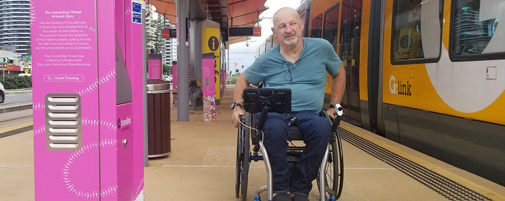
Inclusive mapping gathers data from people using wheelchairs (the 'pilots') equipped with technology that assesses the type of footpath surface and its condition, the effort required to push, footpath hazards and barriers, and the number of kerb ramps. The pilots can also collect information on the amount of shade and navigational signs for people walking. When we talk about walking we include moving with the help of a mobility device (such as a wheelchair, mobility cane or a walking frame).
People with disability can be left stranded by a missing section of footpath or kerb ramps. Uneven surfaces and unprotected crossings can be dangerous. Providing infrastructure that is suitable for people with disability means that everyone benefits: people with prams, children, people with an injury, older people and anyone who wants to walk beside someone else comfortably.
In 2022, we commissioned inclusive mapping for three locations: Broadbeach South Light Rail Station (will service Brisbane 2032 Olympic and Paralympic Games venues), Sunshine Coast University Hospital (regional medical and health hub) and the Warrina Arcade precinct in Townsville (regional community). Across the projects, the pilots:
- assessed 120km of paths or missing paths
- identified 264 footpath hazards and barriers (for example, uneven surface, a pole obstructing the path, or a path that is too close to traffic).
In general, more recently developed areas had better quality footpaths and were more comfortable for people in wheelchairs to use. This reinforces the value of improving guidance to achieve more walkable places.
Our project teams included representatives from planning consultancy firms and local governments in Townsville and on the Gold and Sunshine Coasts. The teams found the inclusive mapping data and pilot experiences invaluable for selecting preferred walking routes and identifying priority actions that could create more inclusive walking environments. Examples include maintaining vegetation to prevent obstructions and providing missing footpaths where people have no option currently but to walk on the road.
We shared the inclusive mapping data with the partner local governments. Sunshine Coast Council and Townsville City Council are developing their own maps to help people with disability get around their cities and the project data will expand the area available for the public to view.
Next steps
Department of Transport and Main Roads and the local governments are integrating actions identified through inclusive mapping into the priority works programs for these locations – see Action 1.4 summary for more information.
Department of Transport and Main Roads will update its walking network planning guidance to encourage users to apply an inclusive planning approach to their projects.
More information
- Watch a video about Department of Transport and Main Roads inclusive mapping process
- Sunshine Coast Council's mobility mapping and Townsville City Council's Mobility in Townsville map.
- Department of Transport and Main Roads inclusive mapping pilot projects.
- Walking network planning projects (Action Summary 1.4)
- Last updated 13 November 2023