
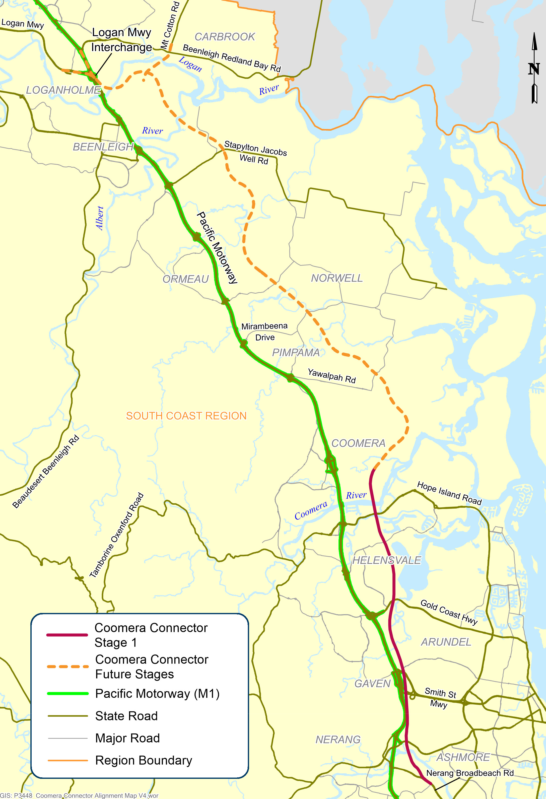
Coomera Connector (Stage 1)
The Stage 1 section of the Coomera Connector between Coomera and Nerang has been identified as the priority section to be built first.
Construction
The Stage 1 section of the Coomera Connector between Coomera and Nerang has been identified as the priority section to be built first.
Construction
Planning is underway for the future stages of the Coomera Connector – the remaining 29km between Loganholme and Coomera.
PlanningThe Coomera Connector (sometimes referred to as the Second M1), is a future state-controlled north-south transport corridor between Loganholme and Nerang, east of the Pacific Motorway (M1) and the heavy train line.
The new road will be an alternative to the M1, providing more transport capacity to support the rapidly growing residential and business communities in the northern Gold Coast and neighbouring Logan areas.
The complete gazetted corridor extends for 45km between the Logan Motorway and Pacific Motorway interchange in Loganholme and Nerang–Broadbeach Road in Nerang.
The Coomera Connector will be delivered in sections:
The Coomera Connector (formerly known as the Intra Regional Transport Corridor) will be a key link in an expanded road transport network between Loganholme and the Gold Coast, where residential and business communities are growing rapidly.
Since the 1990s, the corridor has been identified in various public planning documents, such as published street directories, regional transport plans, planning studies and City of Gold Coast planning schemes.
A joint 2015 study between TMR and City of Gold Coast confirmed the corridor as a future strategic transport link that will relieve traffic congestion on the M1 and surrounding local roads.
The Coomera Connector was formally declared a future state-controlled road, confirmed in the Queensland Government Gazette in 3 sections, the:
Formal confirmation of the corridor in the Queensland Government Gazette allows the corridor to be protected from new development and provides certainty for property owners, business and residential communities on the northern Gold Coast.
Our team continues to liaise with property owners when dealing with land sales and development applications. Early acquisition of properties by TMR may occur in some circumstances.
Initial community consultation on the Coomera Connector was undertaken in late 2019.
The consultation program included a series of 10 community drop-in sessions along the 45km project corridor, plus online engagement activities.
There was significant interest from the community with 3200 visits to the website, more than 2000 people visiting the community drop-in sessions to talk with the project team, and 700 pieces of feedback received.
A telephone survey of 1000 residents and businesses revealed 4 out of 5 people in the project corridor area support the introduction of the Coomera Connector.
Further consultation was carried out in late 2020 and early 2021.
Read more about community consultation for Coomera Connector (Stage 1) and Coomera Connector (Future stages) projects.

Detailed design is underway for a proposed upgrade of the Booral Road and Boundary Road intersection at Urangan.

Planning is underway to improve flood immunity and safety on a section of Booral Road at Bunya Creek, including the Main Street intersection.

We are developing a rail corridor vision and a staged program of rail priorities to 2051 on the North Coast Line between Brisbane and Gympie North.

The $1.162 billion Section D: Woondum to Curra project is a new 26km, 4-lane divided highway between the existing Bruce Highway interchange at Woondum, south of Gympie and Curra.
Planning is complete and the detailed design stage has commenced for a new four-lane section of the Bruce Highway to the east of Tiaro. The project will increase the flood immunity, safety and efficiency of the Bruce Highway and future-proof the road to cater for growing traffic volumes. It will also remove a significant number of heavy vehicles from the Tiaro township, improving safety and liveability for residents.
This project will provide Intelligent Transport System infrastructure at various locations along the Bruce Highway between Pine River and Cairns.
This project involves a 62km realignment and upgrade of the Bruce Highway to 4 lanes between Cooroy and Curra and is among Queensland's highest priority road projects.
The Bundaberg Integrated Transport Strategy is being jointly developed by the Department of Transport and Main Roads and Bundaberg Regional Council to develop an overarching framework that aims to integrate plans and policies, current and future, relating to the movement of people and services.
In October 2007 Transport and Main Roads (then Queensland Transport) engaged GHD to undertake a study to identify a rail corridor (for freight traffic) to connect the Port of Bundaberg to the existing rail network via the North Coast line. The study report determined that protection of the corridor within the local government planning scheme was not warranted at the time, and the project was closed.
Planning is underway for the future stages of the Coomera Connector – the remaining 29km between Loganholme and Coomera.
The Stage 1 section of the Coomera Connector between Coomera and Nerang has been identified as the priority section to be built first.
Coomera Connector (Stage 1) is around 16km long and will be delivered in 3 construction packages. Stage 1 Central, which is currently in the design phase, is the 8km section from Helensvale Road to Smith Street Motorway.
Coomera Connector (Stage 1) is around 16km and will be delivered in 3 construction packages. Stage 1 North, which is currently under construction, is the 4km section from Shipper Drive to Helensvale Road.
Design phase is underway for the Coomera Connector Stage 1 South package from Smith Street Motorway to Nerang-Broadbeach Road.
Construction and design works are underway for upgrades at various locations as part of a program of works to improve the D'Aguilar Highway between Yarraman and Kingaroy.
The department is improving the flood immunity and resilience of the state-controlled road network at 27 priority sites.
Detailed design is underway for active transport bridges and pathways to connect Southside to Gympie's CBD and surrounds.
The department will improve safety on a 40km stretch of the Isis Highway from Airport Drive to the Bruce Highway.
The upgrade of the Maryborough - Hervey Bay Road and Pialba - Burrum Heads Road intersection in Eli Waters will improve traffic movement and the safety of motorists, pedestrians and bicycle riders.
Planning is underway for an upgrade of the Maryborough-Hervey Bay Road, Ibis Boulevard and Fairway Drive intersection.
The department is progressively upgrading and sealing the gravel sections of Monto - Mount Perry Road to improve road user safety and comfort, and reduce future maintenance requirements.

This upgrade will improve flood resilience for Hervey Bay and surrounding communities and involves pavement realignment, widening and culvert upgrades.

Repairs are underway across southern Queensland after extensive and severe damage to the state-controlled road network was caused by multiple heavy rainfall and flooding events in 2022.
Construction will commence this year on a new roundabout at the intersection of Tin Can Bay Road and Bayside Road, at Tin Can Bay.

A new facility is being constructed in the Maryborough region, to manufacture the Queensland Train Manufacturing Program fleet.
Work is underway on flood immunity and intersection upgrades along sections of Torbanlea – Pialba Road between Beelbi Creek and Takura.
Last updated: 6 November 2023