
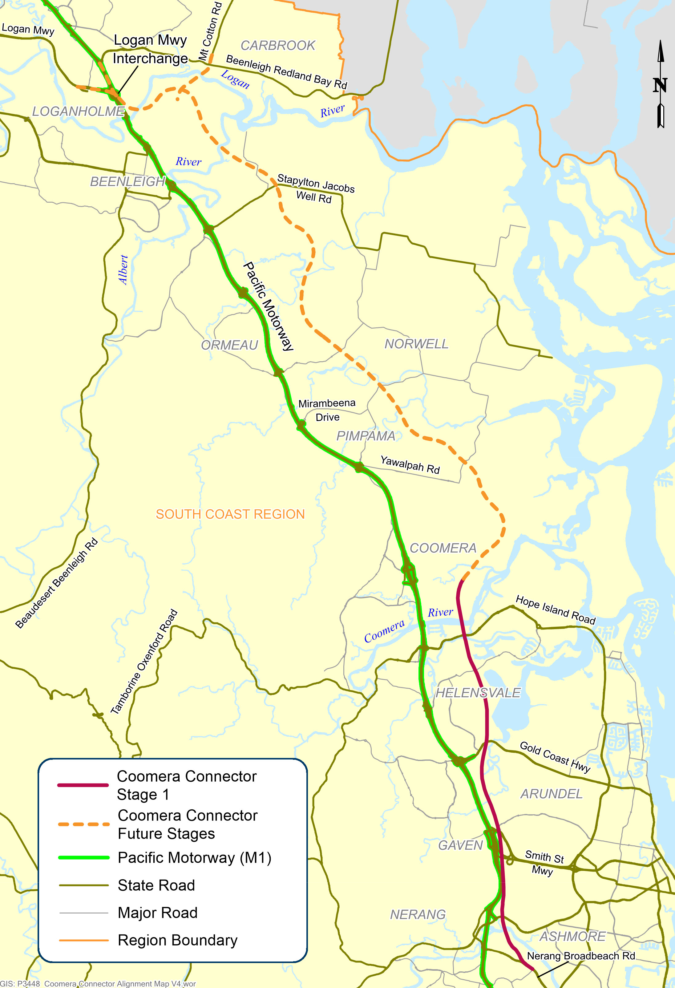
Coomera Connector (Stage 1)
The Stage 1 section of the Coomera Connector between Coomera and Nerang has been identified as the priority section to be built first.
Construction
The Stage 1 section of the Coomera Connector between Coomera and Nerang has been identified as the priority section to be built first.
Construction
Planning is underway for the future stages of the Coomera Connector – the remaining 29km between Loganholme and Coomera.
PlanningThe Coomera Connector (sometimes referred to as the Second M1), is a future state-controlled north-south transport corridor between Loganholme and Nerang, east of the Pacific Motorway (M1) and the heavy train line.
The new road will be an alternative to the M1, providing more transport capacity to support the rapidly growing residential and business communities in the northern Gold Coast and neighbouring Logan areas.
The complete gazetted corridor extends for 45km between the Logan Motorway and Pacific Motorway interchange in Loganholme and Nerang–Broadbeach Road in Nerang.
The Coomera Connector will be delivered in sections:
The Coomera Connector (formerly known as the Intra Regional Transport Corridor) will be a key link in an expanded road transport network between Loganholme and the Gold Coast, where residential and business communities are growing rapidly.
Since the 1990s, the corridor has been identified in various public planning documents, such as published street directories, regional transport plans, planning studies and City of Gold Coast planning schemes.
A joint 2015 study between TMR and City of Gold Coast confirmed the corridor as a future strategic transport link that will relieve traffic congestion on the M1 and surrounding local roads.
The Coomera Connector was formally declared a future state-controlled road, confirmed in the Queensland Government Gazette in 3 sections, the:
Formal confirmation of the corridor in the Queensland Government Gazette allows the corridor to be protected from new development and provides certainty for property owners, business and residential communities on the northern Gold Coast.
Our team continues to liaise with property owners when dealing with land sales and development applications. Early acquisition of properties by TMR may occur in some circumstances.
Initial community consultation on the Coomera Connector was undertaken in late 2019.
The consultation program included a series of 10 community drop-in sessions along the 45km project corridor, plus online engagement activities.
There was significant interest from the community with 3200 visits to the website, more than 2000 people visiting the community drop-in sessions to talk with the project team, and 700 pieces of feedback received.
A telephone survey of 1000 residents and businesses revealed 4 out of 5 people in the project corridor area support the introduction of the Coomera Connector.
Further consultation was carried out in late 2020 and early 2021.
Read more about community consultation for Coomera Connector (Stage 1) and Coomera Connector (Future stages) projects.

The department has delivered safety improvements on sections of the Beaudesert to Beenleigh corridor.

This project will see the road duplicated between Mount Warren Boulevard and Tallagandra Road.
The department is planning for a future upgrade of the intersection of Beenleigh Connection Road (Logan Street) and City Road.
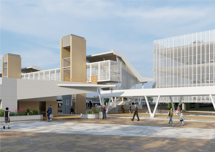
Beenleigh train station is a key transfer location between all-stops and express services on the Beenleigh and Gold Coast train lines.
Planning will be undertaken for the section of the road between Logandale Boulevard and Mount Cotton Road.
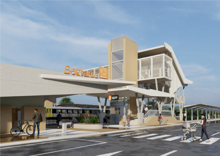
Bethania train station is being upgraded to improve accessibility, safety and customer experience.
This project will provide Intelligent Transport System infrastructure at various locations along the Bruce Highway between Pine River and Cairns.

This intersection is identified for an upgrade due to the rapid expansion of local urban areas, increased traffic volumes and crash history.
Together with the Gold Coast City Council, we are working on the Central Gold Coast East-West Passenger Transport Study.
Planning is underway for the future stages of the Coomera Connector – the remaining 29km between Loganholme and Coomera.
The Stage 1 section of the Coomera Connector between Coomera and Nerang has been identified as the priority section to be built first.
Coomera Connector (Stage 1) is around 16km long and will be delivered in 3 construction packages. Stage 1 Central, which is currently in the design phase, is the 8km section from Helensvale Road to Smith Street Motorway.
Coomera Connector (Stage 1) is around 16km and will be delivered in 3 construction packages. Stage 1 North, which is currently under construction, is the 4km section from Shipper Drive to Helensvale Road.
Design phase is underway for the Coomera Connector Stage 1 South package from Smith Street Motorway to Nerang-Broadbeach Road.
We have upgraded the park 'n' ride facilities at the Coomera train station.

The department is committed to restoring and repairing the damaged section of the Cunningham Highway at Cunninghams Gap. This 2km stretch, leading up to the Allan Cunningham monument, suffered significant road damage during the bushfires in 2019.
Planning is underway to upgrade the Cunningham Highway.
The intersection of Currumbin Creek Road and Bienvenue Drive, at Currumbin Waters will be upgraded.
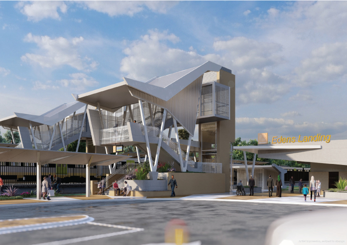
Edens Landing station is being upgraded to improve accessibility, safety and customer experience.
The department is improving the flood immunity and resilience of the state-controlled road network at 27 priority sites.
We are continuing to protect and plan for the Gold Coast heavy rail corridor between Varsity Lakes and Gold Coast Airport.
Planning has started on the proposed Currumbin Creek Active Transport Bridge between Palm Beach and Currumbin.
The department is undertaking planning for future upgrades to the Gold Coast Highway at the intersection of Captain Cook Drive/Pine Ridge Road due to the high volume of traffic causing congestion and delays. The future upgrade aims to improve traffic flow and safety at the intersection

Gold Coast Light Rail is a world class public transport system for residents and visitors to the Gold Coast.
The proposed Gold Coast Light Rail Stage 4 is a world class public transport system for residents and visitors to the Gold Coast.
We are planning for a future upgrade of the Mudgeeraba Creek Causeway on Gold Coast–Springbrook Road, Austinville.
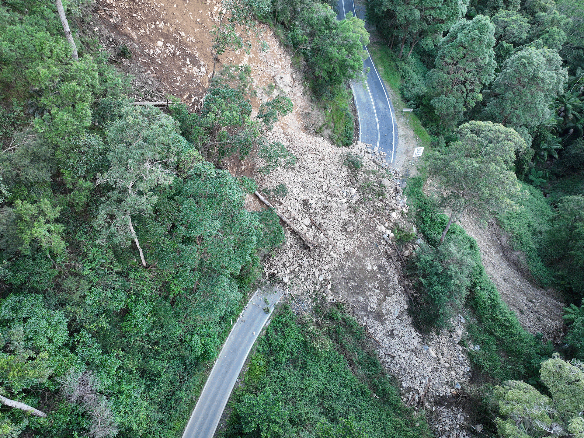
Gold Coast-Springbrook sustained a significant number of landslips, rock falls and tree falls over a 10-kilometre section during extreme rainfall and flooding events from 22 February to 20 May 2022.
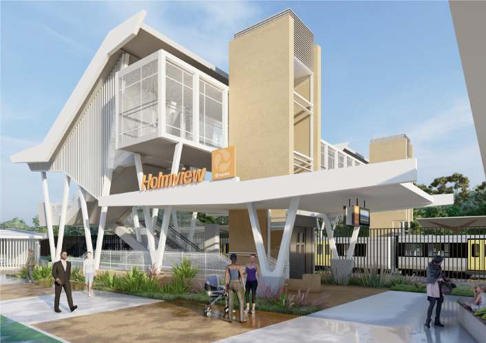
Holmview train station is being upgraded to improve accessibility, safety and customer experience.
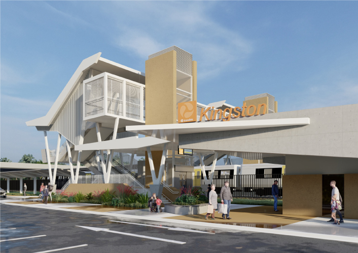
Kingston train station is being upgraded to improve accessibility, safety and customer experience for the community.
Design is underway for a bikeway on Olsen Avenue between the Gold Coast Highway and Napper Road.

The department is working on multiple locations along Lamington National Park Road which require pavement rehabilitation and permanent reconstruction work following record rainfall across south east Queensland since December 2020.
We are relocating Loganlea train station and the park 'n' ride closer to Logan Hospital.
This project is focused on improving safety along various sections of this 36km road where there is a high crash history.

A rail facility is being constructed on a 66ha site in the Gold Coast region.
We have upgraded the car park at the Ormeau station park 'n' ride.

Planning is underway for the Pacific Motorway (M1) – Daisy Hill to Logan Motorway upgrade. This section of the M1 cannot accommodate current traffic volumes and, as a result, experiences frequent and prolonged periods of congestion and poor travel time reliability.

The Sports Drive to Gateway Motorway Upgrade is part of a rolling program of upgrades between the Gateway and Logan Motorways.

The Pacific Motorway (M1) between Watland Street and Sports Drive is being upgraded as part of a rolling program of upgrades between the Gateway and Logan Motorways.
Safety improvements to the Ormeau Interchange (Exit 45) southbound off-ramp on the Pacific Motorway has reduced traffic on the M1 and Lahrs Road.

The M1 between Burleigh and Palm Beach (Package B) is being upgraded as part of the Varsity Lakes to Tugun (VL2T) upgrade. Package B will include significant environmental features through this section of the upgrade.
Planning and construction is underway for short and long-term upgrades of various interchanges on the Pacific Motorway (M1)

We have delivered an upgrade of the M1 between Mudgeeraba and Varsity Lakes to reduce travel time and congestion, improve safety, and increase traffic flow. Interchange enhancements have improved access on and off the motorway.

The Pacific Motorway (M1) is being upgraded between Palm Beach and Tugun (Package C) as part of the Varsity Lakes to Tugun (VL2T) upgrade.

The Pacific Motorway (M1) Varsity Lakes to Tugun (VL2T) is being upgraded and delivered in packages.

The $1.5 billion Pacific Motorway Varsity Lakes to Tugun (VL2T) project is being delivered to upgrade 10km of the M1 and is being constructing in packages to ensure faster delivery and best value for money.

Construction to upgrade the M1/M3 Gateway merge to improve safety and reduce peak hour congestion was completed in May 2020.
Work is being undertaken on the Pacific Motorway, Eight Mile Plains to Daisy Hill Upgrade, to improve 8kms of the Pacific Motorway (M1) between the Gateway Motorway and Watland Street.

The Pacific Highway (western service road) in Slacks Creek was realigned and upgraded as part of the Pacific Motorway, Eight Mile Plains to Daisy Hill Upgrade.

As part of a rolling program of Pacific Motorway (M1) upgrades, detailed design for the Rochedale bus station and park 'n' ride is now complete.
The Yatala South (Exit 41) interchange upgrade on the Pacific Motorway (M1) has resulted in significant enhancements to safety and traffic flow in the area.
The Exit 49 interchange upgrade will deliver significant improvements in safety and traffic flow efficiency by keeping traffic moving through the improved interchange and thereby reducing queuing.
We are preserving the Park Ridge Connector, a future transport corridor to connect communities planned at Park Ridge, Flagstone and Yarrabilba to services and employment.
We are delivering continual maintenance and rehabilitation of state-controlled roads and assets in the South Coast region.
We are planning for a proposed passenger rail line between Salisbury and Beaudesert.

Reconstruction works are underway across the South East Region, including the Gold Coast and Scenic Rim, to repair storm damaged roads.

Repairs are underway across southern Queensland after extensive and severe damage to the state-controlled road network was caused by multiple heavy rainfall and flooding events in 2022.
The department values the protection of native fauna and supports koala protection treatments and initiatives to help mitigate koala-vehicle collisions.
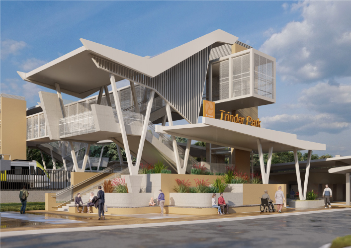
Trinder Park train station is being relocated further north to be more centrally located between the Kuraby and Woodridge train stations. The relocation will improve safety and network efficiency due to its new straightened section of the track.
The Varsity Lakes station park 'n' ride upgrade is delivering close to 350 parking spaces.
Waterford-Tamborine Road is being upgraded in stages.
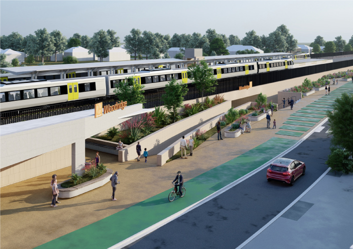
Woodridge station is being upgraded to improve accessibility, safety and customer experience.
Last updated: 6 November 2023