
Coomera Connector (Stage 1)
The Stage 1 section of the Coomera Connector between Coomera and Nerang has been identified as the priority section to be built first.
Construction
The Stage 1 section of the Coomera Connector between Coomera and Nerang has been identified as the priority section to be built first.
Construction
Work is being undertaken on the Pacific Motorway, Eight Mile Plains to Daisy Hill Upgrade, to improve 8kms of the Pacific Motorway (M1) between the Gateway Motorway and Watland Street.
Construction
The $1.5 billion Pacific Motorway Varsity Lakes to Tugun (VL2T) project is being delivered to upgrade 10km of the M1 and is being constructing in packages to ensure faster delivery and best value for money.
ConstructionThe Pacific Motorway M1 is one of Australia’s busiest highways and is a national freight route.
We want you to get where you're going more reliably, so you can spend more time doing the things you love.
The upgrade and widening of the Pacific Motorway M1 is being delivered in strategic priority stages as funding becomes available, based on traffic volumes and best value for money.
| Project | Status |
| Coomera interchange | Completed |
| Coomera Connector Stage 1 | Construction |
| Coomera Connector Future Stages | Planning |
| Daisy Hill to Logan Motorway | Planning |
| Eight Mile Plains to Daisy Hill | Construction |
| Logan Motorway to Palm Beach |
Completed |
| Loganholme to Pimpama |
Planning |
| M1/M3 Gateway Merge | Completed |
| Mudgeeraba to Robina |
Completed |
| Mudgeeraba to Varsity Lakes | Completed |
| Ormeau interchange (Exit 45) southbound off-ramp | Completed |
| Ormeau interchange (North) | Planning |
| Pimpama interchange (Exit 49) | Construction |
| Varsity Lakes to Tugun (Exit 85 to 95) |
Construction |
| Worongary to Mudgeeraba |
Completed |
| Yatala South Interchange (Exit 41) | Completed |
| Main Street overpass safety improvements |
Planning |
| Logan Motorway to Nerang |
Planning |

The department is undertaking the rehabilitation and maintenance program for the Burdekin River Bridge to preserve the structural integrity of the bridge. The ongoing program will ensure a safe and durable crossing is maintained for the long-term use of vehicles, heavy transport operators, rail operations, bicycle riders and pedestrians.

Safety on the Bruce Highway at Inkerman will be improved through the installation of new northbound overtaking opportunity and upgrades to the Mount Inkerman Road intersection.

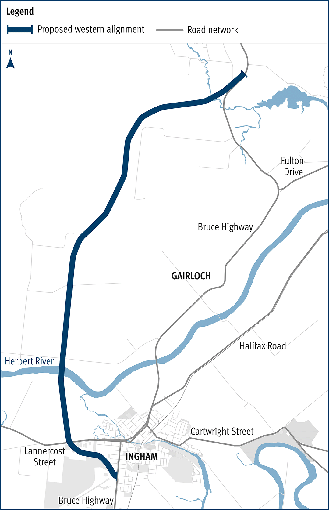
Planning has started to improve safety and reduce the time of closure due to flooding on a complex section of the Bruce Highway at the Gairloch floodway, approximately 6km north of Ingham.
This project will provide Intelligent Transport System infrastructure at various locations along the Bruce Highway between Pine River and Cairns.
Bruce Highway works, between Townsville and Ingham, are underway to improve safety and upgrade a rest area.

Bruce Highway upgrades between Leichhardt Creek and Cassowary Creek (about 42km north of Townsville).
The department has been actively working with the community to address the challenges associated with the Bruce Highway from South of Ingham to the Cardwell Range.

Planning is underway for the future stages of the Coomera Connector – the remaining 29km between Loganholme and Coomera.
The Stage 1 section of the Coomera Connector between Coomera and Nerang has been identified as the priority section to be built first.
Coomera Connector (Stage 1) is around 16km long and will be delivered in 3 construction packages. Stage 1 Central, which is currently in the design phase, is the 8km section from Helensvale Road to Smith Street Motorway.
Coomera Connector (Stage 1) is around 16km and will be delivered in 3 construction packages. Stage 1 North, which is currently under construction, is the 4km section from Shipper Drive to Helensvale Road.
Design phase is underway for the Coomera Connector Stage 1 South package from Smith Street Motorway to Nerang-Broadbeach Road.

Safety upgrades will be carried out at various locations along Douglas – Garbutt Road.
This project will deliver upgrades to Riverway Drive, between Allambie Lane and Dunlop Street, to improve safety and alleviate traffic congestion.
The package of Gregory Developmental Road upgrades is delivering a stronger and wider surface, improving travelling conditions for motorists and upgraded a major culvert to improve flood resilience.
The Townsville City Centre to James Cook University bikeway planning project will establish a long-term vision to provide a fit-for-purpose, interconnected and safe bike route between the Townsville City Centre and the University Drive underpass in Annandale.

Safety upgrades will be carried out at various locations along North Ward Road.

Planning is underway for the Pacific Motorway (M1) – Daisy Hill to Logan Motorway upgrade. This section of the M1 cannot accommodate current traffic volumes and, as a result, experiences frequent and prolonged periods of congestion and poor travel time reliability.
Planning and construction is underway for short and long-term upgrades of various interchanges on the Pacific Motorway (M1)

We have delivered an upgrade of the M1 between Mudgeeraba and Varsity Lakes to reduce travel time and congestion, improve safety, and increase traffic flow. Interchange enhancements have improved access on and off the motorway.
The $1.5 billion Pacific Motorway Varsity Lakes to Tugun (VL2T) project is being delivered to upgrade 10km of the M1 and is being constructing in packages to ensure faster delivery and best value for money.

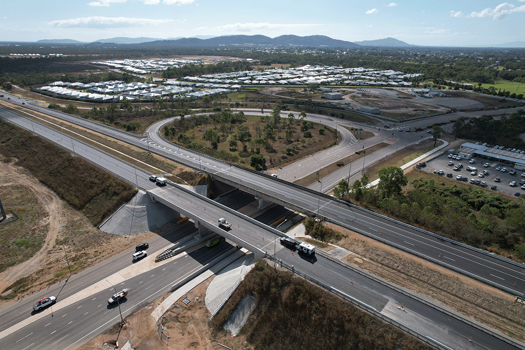
Construction to upgrade the M1/M3 Gateway merge to improve safety and reduce peak hour congestion was completed in May 2020.
Work is being undertaken on the Pacific Motorway, Eight Mile Plains to Daisy Hill Upgrade, to improve 8kms of the Pacific Motorway (M1) between the Gateway Motorway and Watland Street.
The Yatala South (Exit 41) interchange upgrade on the Pacific Motorway (M1) has resulted in significant enhancements to safety and traffic flow in the area.
The Exit 49 interchange upgrade will deliver significant improvements in safety and traffic flow efficiency by keeping traffic moving through the improved interchange and thereby reducing queuing.
The Townsville Connection Road is being upgraded to dual lanes between University Road and Bowen Road Bridge. The project includes upgrades at 3 intersections: Gartrell Drive, Mervyn Crossman Drive/Fairfield Waters Drive and Kokoda Street.
The department is building a new upstream bridge over the Ross River in Townsville, adjacent to the existing Bowen Road Bridge. This will increase the capacity of the river crossing from 2 to 4 lanes.

We are planning for the Townsville Eastern Access Rail Corridor (TEARC) project, a proposed 8.3km rail freight line connecting the North Coast rail line directly into the Port of Townsville.
The Townsville Ring Road Stage 5 project, a landmark initiative that has brought about substantial improvements in road safety, traffic flow and travel time predictability for both freight and passenger vehicles along the Bruce Highway in Townsville, has been completed.
Last updated: 23 July 2024