
Caboolture–Bribie Island Road, Bribie Island bridge, planning
The department is finalising a business case for the construction of a new bridge to Bribie Island.
Planning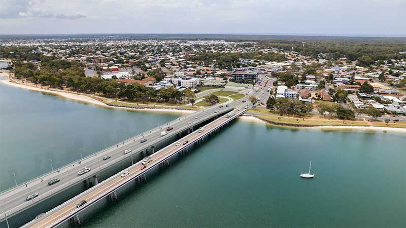
The department is finalising a business case for the construction of a new bridge to Bribie Island.
Planning
The future duplication of Caboolture-Bribie Island Road between King Johns Creek and Hickey Road will ease congestion and improve safety.
Detailed design
The department is undertaking detailed design for the duplication of Caboolture-Bribie Island Road between Old Toorbul Point Road and Saint Road, including signalisation of the Volz Road intersection.
Detailed designThe department is planning sequential upgrades to improve safety, ease congestion and improve traffic flow and connectivity on critical sections of Caboolture-Bribie Island Road.
The road will be upgraded to 4 lanes, with a median-divided cross section for its entire length.
The department has developed the Bribie Island Road Upgrade Strategy which identifies a program of works to deliver upgrade projects sequentially on Caboolture-Bribie Island Road.
As projects are progressed, consultation with key stakeholders and the community will be undertaken.
Upgrading Caboolture-Bribie Island Road will help ease congestion, improve safety and flood immunity in critical areas.
Construction of the Old Toorbul Point Road intersection upgrade was completed in early October 2021. The upgrade of Regina Avenue intersection to install new traffic signals was completed in March 2023. Detailed design is underway for the duplication of Caboolture-Bribie Island Road between Old Toorbul Point Road and Saint Road, including signalisation of the Volz Road intersection. Planning for the future duplication of Caboolture-Bribie Island Road between King Johns Creek and Hickey Road is underway. A business case is underway for a new Bribie Island Bridge.
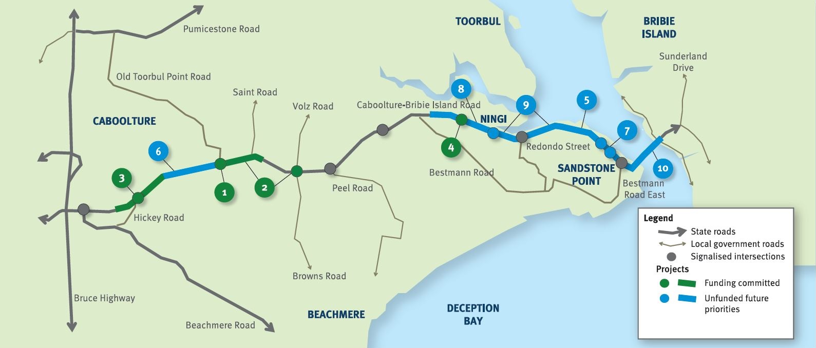
The Australian Government and Queensland Government are funding 4 projects under this program.
The Australian Government has committed $38.91 million and the Queensland Government has committed $49.68 million to progress priority upgrades. Investment IDs 1158882, 1779573, 1862714 and 489249.
The Australian Government’s independent Strategic Review of its Infrastructure Investment Program allocated an additional $8,915,000 by the Australian Government. Project cost and funding contributions under this program are subject to further consideration and negotiation.
Funding figures updated December 2023 to reflect increased Australian Government contributions.

Upgrades to improve flood immunity at Jumper Creek, between Mackay and Proserpine are now complete.
The Bruce Highway upgrade project at Goorganga Plains and Myrtle Creek, near Proserpine, aims to plan and preserve the road corridor to enhance flood immunity and address access issues during wet weather events.
Construction has started at the Knobels Road and Nebia Coningsby Road intersection to improve safety and enhance visibility.
This project will provide Intelligent Transport System infrastructure at various locations along the Bruce Highway between Pine River and Cairns.
Safety upgrades have been completed to almost 20km of the Bruce Highway from Proserpine to Bowen, as part of the Bruce Highway Upgrade Program.
The future duplication of Caboolture-Bribie Island Road between King Johns Creek and Hickey Road will ease congestion and improve safety.
The department is undertaking detailed design for the duplication of Caboolture-Bribie Island Road between Old Toorbul Point Road and Saint Road, including signalisation of the Volz Road intersection.
The department is finalising a business case for the construction of a new bridge to Bribie Island.

Eton Range fully opened to traffic on 1 October 2020. The existing range has been upgraded to 4 lanes, added a split carriageway for part of the range and reduced the grade to improve safety and efficiency.
Mackay Port Access will provide a direct link for freight movements from the Mackay Port to the Mackay Ring Road, and west to the Bowen Basin coal fields via the Walkerston Bypass and Peak Downs Highway.

An improved link has been delivered from the south to the northern suburbs reducing traffic through Mackay.
Planning is underway to identify potential future upgrades to Mackay – Bucasia Road to improve congestion, safety, and flooding impacts on this vital link to the Northern Beaches.
An upgrade is being delivered to a 1.5km section of Proserpine-Shute Harbour Road in Cannonvale.
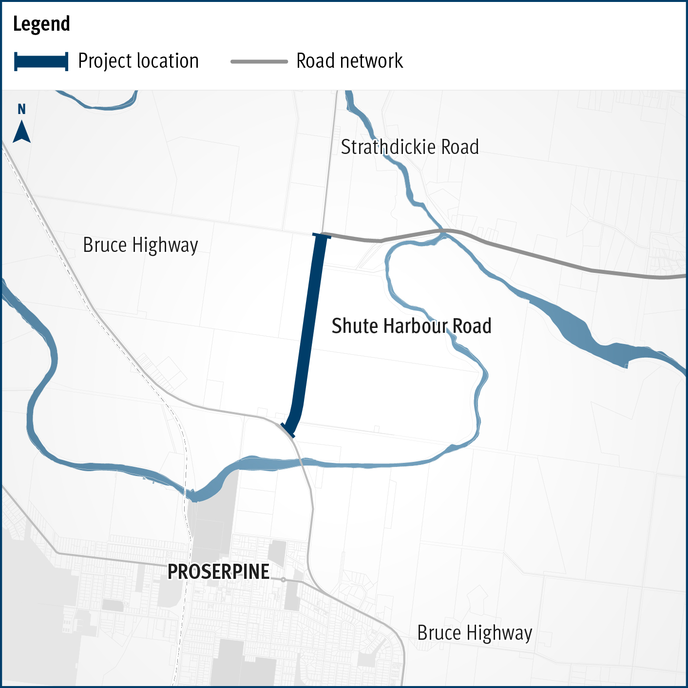
A flood immunity upgrade will be delivered to a 1.5km section of Proserpine – Shute Harbour Road at Hamilton Plains between the Bruce Highway turn-off and Strathdickie Road.

The Walkerston Bypass will deliver a new 2-lane rural highway to connect Peak Downs Highway west of Walkerston to the Mackay Ring Road near Paget.
Last updated: 11 June 2024