
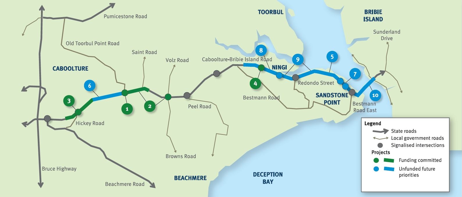
Caboolture–Bribie Island Road, Bribie Island bridge, planning
The department is finalising a business case for the construction of a new bridge to Bribie Island.
Planning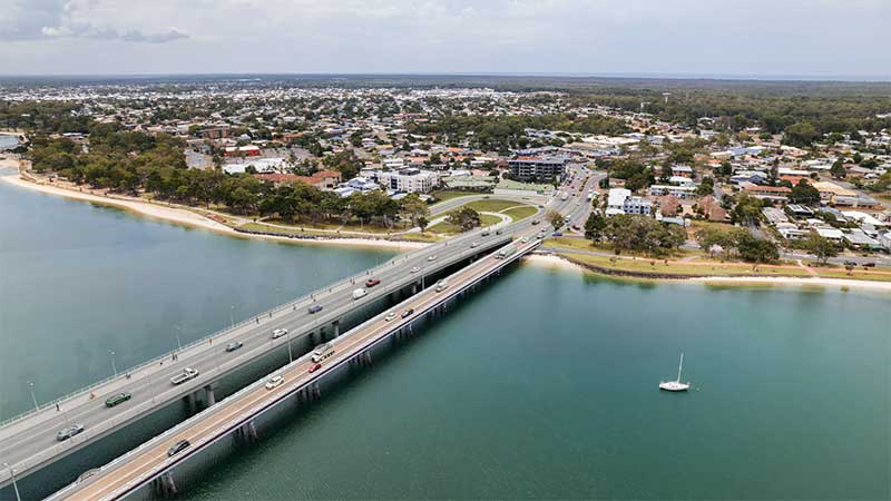
The department is finalising a business case for the construction of a new bridge to Bribie Island.
Planning
The future duplication of Caboolture-Bribie Island Road between King Johns Creek and Hickey Road will ease congestion and improve safety.
Detailed design
The department is undertaking detailed design for the duplication of Caboolture-Bribie Island Road between Old Toorbul Point Road and Saint Road, including signalisation of the Volz Road intersection.
Detailed designThe department is planning sequential upgrades to improve safety, ease congestion and improve traffic flow and connectivity on critical sections of Caboolture-Bribie Island Road.
The road will be upgraded to 4 lanes, with a median-divided cross section for its entire length.
The department has developed the Bribie Island Road Upgrade Strategy which identifies a program of works to deliver upgrade projects sequentially on Caboolture-Bribie Island Road.
As projects are progressed, consultation with key stakeholders and the community will be undertaken.
Upgrading Caboolture-Bribie Island Road will help ease congestion, improve safety and flood immunity in critical areas.
Construction of the Old Toorbul Point Road intersection upgrade was completed in early October 2021. The upgrade of Regina Avenue intersection to install new traffic signals was completed in March 2023. Detailed design is underway for the duplication of Caboolture-Bribie Island Road between Old Toorbul Point Road and Saint Road, including signalisation of the Volz Road intersection. Planning for the future duplication of Caboolture-Bribie Island Road between King Johns Creek and Hickey Road is underway. A business case is underway for a new Bribie Island Bridge.
The Australian Government and Queensland Government are funding 4 projects under this program.
The Australian Government has committed $38.91 million and the Queensland Government has committed $49.68 million to progress priority upgrades. Investment IDs 1158882, 1779573, 1862714 and 489249.
The Australian Government’s independent Strategic Review of its Infrastructure Investment Program allocated an additional $8,915,000 by the Australian Government. Project cost and funding contributions under this program are subject to further consideration and negotiation.
Funding figures updated December 2023 to reflect increased Australian Government contributions.

The department has built a southbound overtaking lane and fauna crossing at Smiths Gap on the Bruce Highway.
The department is progressing a $9 million planning project to plan and protect a suitable road corridor for a future bypass of Innisfail, if required.
The department is progressing a project to upgrade the intersection of the Bruce Highway and Munro Street at Babinda.
This project will provide Intelligent Transport System infrastructure at various locations along the Bruce Highway between Pine River and Cairns.
A total transport solution has been delivered to provide long-term improvements to traffic flow and road safety through reducing congestion, highway travel time and improving road access.
Planning for the Bruce Highway, Cairns Southern Access Corridor (Stage 5), Foster Road upgrade intersection project will assess and recommend options to upgrade this intersection.
The future duplication of Caboolture-Bribie Island Road between King Johns Creek and Hickey Road will ease congestion and improve safety.
The department is undertaking detailed design for the duplication of Caboolture-Bribie Island Road between Old Toorbul Point Road and Saint Road, including signalisation of the Volz Road intersection.
The department is finalising a business case for the construction of a new bridge to Bribie Island.
The Cairns Bruce Highway Upgrade master plan was released in 2010. It was the result of a planning study that investigated long term, multi-modal transport planning options to address the impacts of urban growth, congestion and traffic accidents.

The Department is reinvesting project savings to deliver a new off-road cycleway next to the Bruce Highway, consistent with the Cairns Bruce Highway Upgrade Masterplan. The project will deliver a safe off-road facility for bicycle riders of all abilities, including school children and the active transport community. The new cycleway also delivers a direct and continuous route with limited intersections to encourage bicycle riders to use the off-road facility.
Cairns Transit Network is the first busway planning project of its kind in regional Queensland. It will improve public transport in Cairns by giving buses priority, either in separate bus lanes or on dedicated bus-only lanes (busways) which will be separated from general traffic.
By 2046, the Cairns local government area is expected to increase by approximately 59,000 residents. In addition to the substantial visitor numbers in the region, this significant residential growth will have an impact on the safety, efficiency and accessibility of the Cairns urban transport network.
Taking a holistic approach to the planning of this expected growth will ensure a sustainable, efficient and accessible transport network in the region.
The department is undertaking a $300 million project to duplicate the Cairns Western Arterial Road between Redlynch Connector Road and Captain Cook Highway.
The department has completed a comprehensive planning study into the 4 transport corridors linking Cairns to the Northern Tablelands.
The Cape York Region Package Stage 2 is a program of works to deliver infrastructure upgrades on the Cape York Peninsula between 2019-2020 and 2023-2024.
Master planning is progressing on the Captain Cook Highway between Cairns CBD and Smithfield.
The Gulf Developmental Road is the principal freight and tourism route connecting Carpentaria Shire via the Kennedy Highway, with the Bruce Highway coastal link. The road is sealed, however there are 19 sections spread over 47kms that are only single lane.

The Barron River bridge planning project aims to explore long-term, sustainable solutions for the bridge located near Kuranda.
Intelligent Transport Systems (ITS) treatments on Kuranda Range Road have been installed. The Intelligent Transport System treatments will make it quicker and easier to manage incidents and reduce the risk of crashes.

This project will progress planning for the southern section of the Mareeba Bypass and review the alignment of the northern section.
We are constructing a new recreational boat launching facility at Yorkeys Knob.
Last updated: 11 June 2024