
Caboolture–Bribie Island Road, Bribie Island bridge, planning
The department is finalising a business case for the construction of a new bridge to Bribie Island.
Planning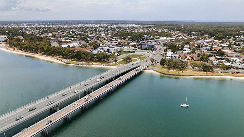
The department is finalising a business case for the construction of a new bridge to Bribie Island.
Planning
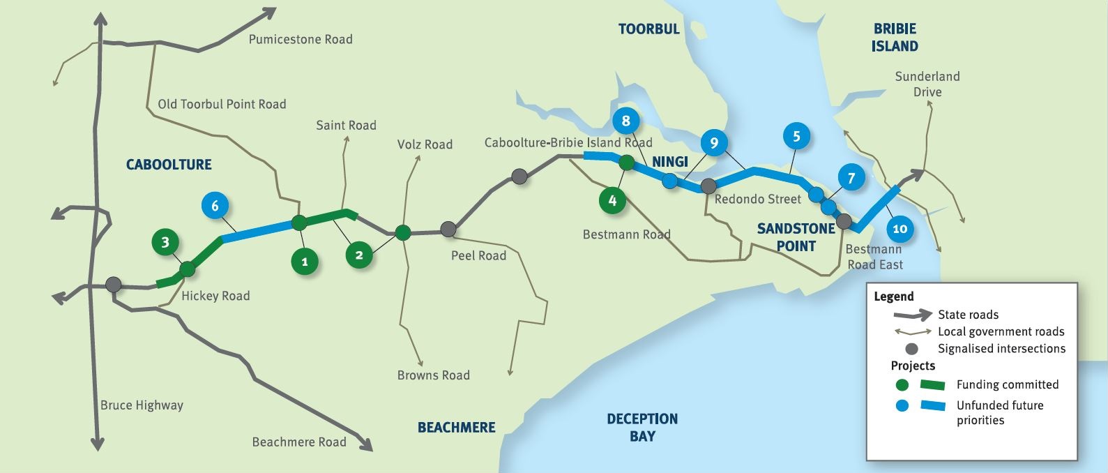
The future duplication of Caboolture-Bribie Island Road between King Johns Creek and Hickey Road will ease congestion and improve safety.
Detailed design
The department is undertaking detailed design for the duplication of Caboolture-Bribie Island Road between Old Toorbul Point Road and Saint Road, including signalisation of the Volz Road intersection.
Detailed designThe department is planning sequential upgrades to improve safety, ease congestion and improve traffic flow and connectivity on critical sections of Caboolture-Bribie Island Road.
The road will be upgraded to 4 lanes, with a median-divided cross section for its entire length.
The department has developed the Bribie Island Road Upgrade Strategy which identifies a program of works to deliver upgrade projects sequentially on Caboolture-Bribie Island Road.
As projects are progressed, consultation with key stakeholders and the community will be undertaken.
Upgrading Caboolture-Bribie Island Road will help ease congestion, improve safety and flood immunity in critical areas.
Construction of the Old Toorbul Point Road intersection upgrade was completed in early October 2021. The upgrade of Regina Avenue intersection to install new traffic signals was completed in March 2023. Detailed design is underway for the duplication of Caboolture-Bribie Island Road between Old Toorbul Point Road and Saint Road, including signalisation of the Volz Road intersection. Planning for the future duplication of Caboolture-Bribie Island Road between King Johns Creek and Hickey Road is underway. A business case is underway for a new Bribie Island Bridge.
The Australian Government and Queensland Government are funding 4 projects under this program.
The Australian Government has committed $38.91 million and the Queensland Government has committed $49.68 million to progress priority upgrades. Investment IDs 1158882, 1779573, 1862714 and 489249.
The Australian Government’s independent Strategic Review of its Infrastructure Investment Program allocated an additional $8,915,000 by the Australian Government. Project cost and funding contributions under this program are subject to further consideration and negotiation.
Funding figures updated December 2023 to reflect increased Australian Government contributions.

The Beerburrum to Nambour Rail Upgrade will provide additional track capacity and reliability, creating travel time savings and increased passenger and freight services to the growing Sunshine Coast region.

A study investigating transport issues and opportunities relating to movement to, from and within the Bribie Island and surrounding area to identify opportunities for further action.
Improvements to approximately 14km of the Brisbane Valley Highway will reduce the rate and severity of crashes and improve traffic efficiency.
Dedicated right-turn lanes, pedestrian refuges, reduced speed limits, and town entry treatments will improve safety for road users through Main Street in Fernvale.

The department is planning to upgrade the Bruce Highway from Anzac Avenue, North Lakes to Uhlmann Road, Burpengary.

The department is planning to upgrade the Bruce Highway from Buchanan Road, Morayfield to Caboolture-Bribie Island, Caboolture.
Major construction was completed for the Bruce Highway Upgrade — Caboolture-Bribie Island Road to Steve Irwin Way project in April 2024. This project widened the 11km stretch of the Bruce Highway from 4 to 6 lanes between Caboolture-Bribie Island Road and Steve Irwin Way (Exit 163). This also included upgrading creek crossings to improve flood immunity at Lagoon, King Johns, Six Mile, Un-named and Beerburrum Creeks.

The Bruce Highway - Gateway Motorway to Dohles Rocks Road (Stage 1) project is part of integrated planning for the Gateway Motorway and Bruce Highway Upgrades in north Brisbane and the Moreton Bay Region.
The Bruce Highway - Gateway Motorway to Dohles Rocks Road (Stage 2) project is part of integrated planning for the Gateway Motorway and Bruce Highway Upgrades in north Brisbane and the Moreton Bay Region.

The department is planning to upgrade the Bruce Highway from the Uhlmann Road, Burpengary to Buchanan Road, Morayfield.

The department is delivering staged upgrades to manage increasing traffic demands on this section of the Bruce Highway. Stage 1 includes extended north-facing ramps from Dohles Rocks Road to Anzac Avenue.
This project will provide Intelligent Transport System infrastructure at various locations along the Bruce Highway between Pine River and Cairns.
The department has delivered a planning project to investigate and prioritise upgrades to the Bruce Highway between the Pine River and Caloundra Road.
A planning study has been undertaken to investigate future upgrade requirements on the Bruce Highway between Deception Bay Road and Caboolture-Bribie Island Road.
We have completed early planning to determine future upgrade needs for the Bruce Highway between the Sunshine Motorway and Maroochydore Road. The planning identifies a long-term solution to meet future traffic growth, reduce traffic congestion, and improve safety and flood immunity.
The Bruce Highway - Pine River to Caloundra Road Smart Motorways (Stage 2) project will deliver additional Smart Motorways technology along a 60km section of the Bruce Highway between the Pine River and Caloundra Road.
Construction is underway to implement safety improvements for Caboolture – Beachmere Road (locally known as Beachmere Road) and enhance overall driving conditions.
The future duplication of Caboolture-Bribie Island Road between King Johns Creek and Hickey Road will ease congestion and improve safety.
The department is undertaking detailed design for the duplication of Caboolture-Bribie Island Road between Old Toorbul Point Road and Saint Road, including signalisation of the Volz Road intersection.
The department is finalising a business case for the construction of a new bridge to Bribie Island.
Options to improve safety and reduce congestion are being investigated at the Caloundra Road, Kawana Way Link Road and Bells Creek Arterial Road intersection in Caloundra.
The department has started planning for an off-road cycle link along approximately 3.5km of Caloundra Road.

A pedestrian overpass over Elizabeth Avenue was installed to provide a safe crossing facility between Clontarf Beach State High School's main campus and Department of Education fields across the road.
The Buaraba Creek timber bridge replacement project will improve safety and network reliability by replacing the existing narrow, timber bridge (Neithe Bridge) with a new wider, two-lane, concrete structure in the same location.

Planning has been undertaken for the upgrade of the intersections at Diamond and Elm Streets and Myall and Elm Streets at Cooroy.
On-road bicycle lanes are being constructed to improve safety at Marcoola and Mudjimba.

Planning is underway to develop a long-term vision for the future of Brisbane-Woodford Road (known as Dayboro Road) between Gympie Road and Youngs Crossing Road.
We’re directly connecting the eastern communities of the Sunshine Coast to South East Queensland’s passenger rail network – making it easier to travel locally, and to and from the Sunshine Coast.
Construction is underway for safety improvements on Eumundi—Noosa Road for all road users, including bike riders.
The department will deliver a new signalised intersection on Glass House Mountains Road, known locally as Steve Irwin Way, at Caloundra Street, Landsborough.
This project will improve safety at various locations along Glass House Mountains Road (locally known as Steve Irwin Way) between Glass House Mountains and Beerwah.

Options are being investigated for a new motorway link (Kawana Motorway) between Parrearra and Meridan Plains. This new motorway will help cater for the growing population.
Design and construction to rehabilitate and widen priority sections of Kin Kin Road (locally known as Pomona Kin Kin Road) is underway. This will improve safety, reduce maintenance costs and improve ride quality on Kin Kin Road.
We've completed extensive investigations on our operational management of Kin Kin Road in response to community concerns around heavy vehicle traffic.
The Six Mile Creek timber bridge on Kin Kin Road, 3km north of Pomona, has been replaced with a concrete bridge structure.
We have identified and preserved a new rail corridor between Landsborough and Nambour, which will replace the existing North Coast line through this section.
Construction has started on widening and sealing 2 sections of Maleny-Kenilworth Road in the Conondale and Cambroon areas to provide a sealed lane and shoulder in each direction.
Construction is complete for safer pedestrian crossings in Maroochydore's entertainment precinct.

Planning will identify a preferred option for a future upgrade that improves efficiency, safety, and reliability for all road users. Active transport facilities will be among the key considerations.
The department has identified a preferred option for the future upgrade of Maroochydore Road, Kunda Park to improve the existing transport network by enhancing network reliability and improving access options.
Construction is underway for safety improvements to the intersections of Bradman Avenue/Diura Street and Bradman Avenue/Denna Street, Maroochydore.
The department is undertaking planning for the full length of Maroochydore–Noosa Road which runs from Ocean Street, Maroochydore to Emu Mountain Road, Peregian Springs.
We are planning for a long-term solution to improve safety and accessibility for all users.
The Mooloolaba Road and Sugar Road intersection project is an interim measure to better manage traffic flow. An upgrade to the intersection will help to minimise delays, congestion and queuing, and improve safety along this busy section of the network.

The department is partnering with Sunshine Coast Council to deliver the Mooloolaba to Maroochydore cycleway which will provide a bicycle path connecting Mooloolaba to Maroochydore.

An ultimate project footprint has been identified for the Caloundra Transport Corridor Upgrade, including the Nicklin Way, Third Avenue extension.
The Australian and Queensland governments have jointly funded planning to address current and emerging transport issues in the Bruce Highway corridor.
In July 2019, RoadTek and Downer were awarded 5-year contracts to provide responsive, routine and programmed maintenance services across the North Coast Region.
Construction is underway for a project to improve safety along a 1.5-km section of Samford Road, between Lomandra Access Road picnic area and Camp Mountain Road, and at the Camp Mountain Road intersection.

Scarborough Boat Harbour is a vibrant part of the Redcliffe Peninsula community. We are currently undertaking a master planning process to help guide future activities at the boat harbour.

Repairs are underway across southern Queensland after extensive and severe damage to the state-controlled road network was caused by multiple heavy rainfall and flooding events in 2022.
A study is underway to identify and prioritise road network connectivity and safety improvements to increase road capacity within the growing southern Sunshine Coast area.
Construction is underway for safety improvements on Strathpine-Samford Road between Eatons Hill and Samford Valley.
The department is undertaking a detailed business case for an improved public transport system for the Sunshine Coast.
The department is planning to duplicate the Sunshine Motorway, between David Low Way to just north of Yandina-Coolum Road.
The department is planning to improve efficiency, capacity and safety on the Sunshine Motorway between the Mooloolah River and the Maroochy River.
The department is planning to improve a section of the Sunshine Motorway between Dixon Road, Buderim and the Mooloolah River Interchange.
The Sunshine Motorway, Mooloolah River Interchange Upgrade will address well-known safety and congestion issues that are forecast to increase due to regional population growth and development, while also delivering improved north-south connectivity on the Sunshine Coast.
Construction is underway to replace the roundabout with a signalised intersection.
Last updated: 11 June 2024