
Caboolture–Bribie Island Road, Bribie Island bridge, planning
The department is finalising a business case for the construction of a new bridge to Bribie Island.
Planning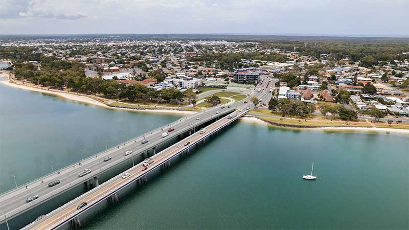
The department is finalising a business case for the construction of a new bridge to Bribie Island.
Planning
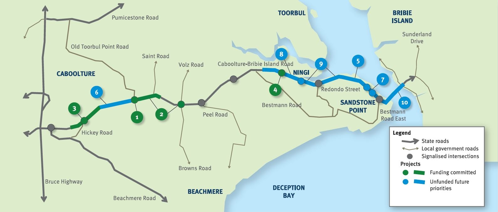
The future duplication of Caboolture-Bribie Island Road between King Johns Creek and Hickey Road will ease congestion and improve safety.
Detailed design
The department is undertaking detailed design for the duplication of Caboolture-Bribie Island Road between Old Toorbul Point Road and Saint Road, including signalisation of the Volz Road intersection.
Detailed designThe department is planning sequential upgrades to improve safety, ease congestion and improve traffic flow and connectivity on critical sections of Caboolture-Bribie Island Road.
The road will be upgraded to 4 lanes, with a median-divided cross section for its entire length.
The department has developed the Bribie Island Road Upgrade Strategy which identifies a program of works to deliver upgrade projects sequentially on Caboolture-Bribie Island Road.
As projects are progressed, consultation with key stakeholders and the community will be undertaken.
Upgrading Caboolture-Bribie Island Road will help ease congestion, improve safety and flood immunity in critical areas.
Construction of the Old Toorbul Point Road intersection upgrade was completed in early October 2021. The upgrade of Regina Avenue intersection to install new traffic signals was completed in March 2023. Detailed design is underway for the duplication of Caboolture-Bribie Island Road between Old Toorbul Point Road and Saint Road, including signalisation of the Volz Road intersection. Planning for the future duplication of Caboolture-Bribie Island Road between King Johns Creek and Hickey Road is underway. A business case is underway for a new Bribie Island Bridge.
The Australian Government and Queensland Government are funding 4 projects under this program.
The Australian Government has committed $38.91 million and the Queensland Government has committed $49.68 million to progress priority upgrades. Investment IDs 1158882, 1779573, 1862714 and 489249.
The Australian Government’s independent Strategic Review of its Infrastructure Investment Program allocated an additional $8,915,000 by the Australian Government. Project cost and funding contributions under this program are subject to further consideration and negotiation.
Funding figures updated December 2023 to reflect increased Australian Government contributions.

Pavement widening on the Barwon Highway has been completed to improve road safety, reduce ongoing maintenance demand and provide a better driving experience for road users in the area.
This project will provide Intelligent Transport System infrastructure at various locations along the Bruce Highway between Pine River and Cairns.
The future duplication of Caboolture-Bribie Island Road between King Johns Creek and Hickey Road will ease congestion and improve safety.
The department is undertaking detailed design for the duplication of Caboolture-Bribie Island Road between Old Toorbul Point Road and Saint Road, including signalisation of the Volz Road intersection.
The department is finalising a business case for the construction of a new bridge to Bribie Island.

A major intersection upgrade to improve safety at the Cunningham and New England highways intersection is complete.
The project involves investigating safety improvements to provide a better driving experience for all road users and reduce the risk of fatal and serious injury crashes.
This project involves investigating safety improvements to provide a better driving experience for all road users and reduce the risk of fatal and serious injury crashes.
The department is improving the flood immunity and resilience of the state-controlled road network at 27 priority sites.
Traffic flow and safety are being improved on Gatton-Helidon Road.

This planning project aims to identify a new permanent alignment for Gatton–Clifton Road to bypass a 400m section that is affected and at-risk from a large and slow-moving landslip at Mount Whitestone.
A new bridge at Wyaga Creek crossing on the Gore Highway will improve flood immunity, safety and efficiency on one of Queensland's most important transport links.
This project has trialled sustainable pavement systems and products to rehabilitate deteriorating sections of the Gore Highway.

Rocky Creek Bridge was replaced to improve safety, traffic flow, flood immunity and efficiency.

Construction is complete to improve safety on Ruthven Street in Toowoomba's south.
This planning project involved investigating ways to improve safety and efficiency on the New England Highway between Hodgson Creek and the southern side of Cambooya Connection Road.

The planning projects investigated future infrastructure to improve safety and efficiency on the New England Highway, south of Toowoomba.

The department has delivered pavement widening and resurfacing works to improve safety and freight efficiency on the New England Highway between Stanthorpe and Ballandean.
The department has a planning project underway to investigate safety improvements at Back Creek on the New England Highway south of Cooyar.
The department is working with the Department of Defence to upgrade the entrance to the Borneo Barracks from the New England Highway at Cabarlah.

The bikeway project will connect Highfields to Toowoomba, providing a safer and more accessible active transport option.

The upgrade of the New England Highway between Cooyar and Bum Bum Creek has been completed, delivering critical safety and efficiency improvements south of Yarraman.
Planning is underway to improve safety, efficiency and reliability of Oakey-Pittsworth Road.

Repairs are underway across southern Queensland after extensive and severe damage to the state-controlled road network was caused by multiple heavy rainfall and flooding events in 2022.
This planning project established a long-term vision to provide suitable active transport facilities between Tor and Boundary streets encourage more people to ride more often.
Planning is underway for another key link in Toowoomba's Principal Cycle Network.
The department has finalised planning on the Toowoomba North South Transport Corridor.
The Australian and Queensland governments are working together to deliver the Toowoomba to Brisbane Passenger Rail Strategic Business Case.

The Australian and Queensland governments are working together to deliver the Toowoomba to Gladstone Inland Rail Extension Business Case.
Detailed design commenced in October 2023 and is expected to be completed in June 2024.
The Warrego Highway East master plan project will determine the future requirements of the Warrego Highway transport corridor.

This project is part of a state-wide strategy to help improve bicycle riding facilities and networks in Warwick to increase active transport.
Last updated: 11 June 2024