
Caboolture–Bribie Island Road, Bribie Island bridge, planning
The department is finalising a business case for the construction of a new bridge to Bribie Island.
Planning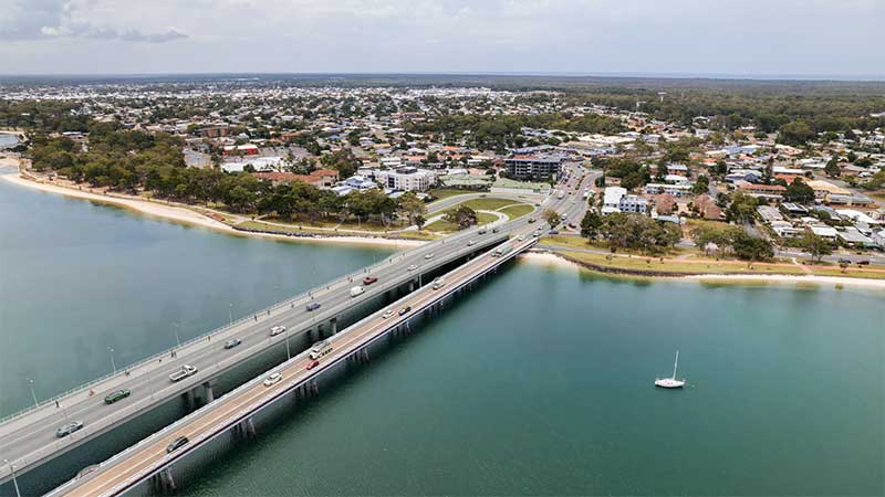
The department is finalising a business case for the construction of a new bridge to Bribie Island.
Planning
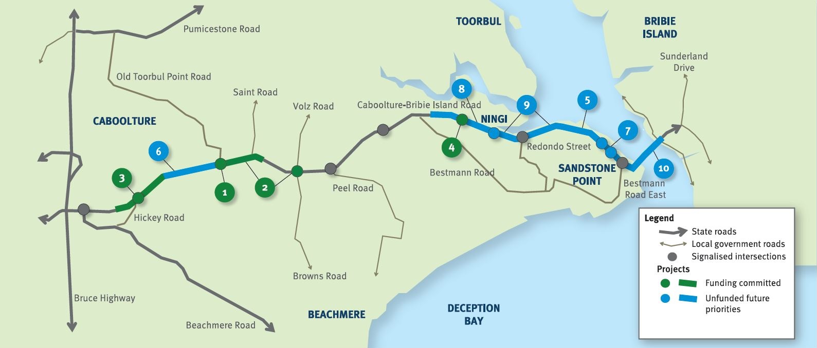
The future duplication of Caboolture-Bribie Island Road between King Johns Creek and Hickey Road will ease congestion and improve safety.
Detailed design
The department is undertaking detailed design for the duplication of Caboolture-Bribie Island Road between Old Toorbul Point Road and Saint Road, including signalisation of the Volz Road intersection.
Detailed designThe department is planning sequential upgrades to improve safety, ease congestion and improve traffic flow and connectivity on critical sections of Caboolture-Bribie Island Road.
The road will be upgraded to 4 lanes, with a median-divided cross section for its entire length.
The department has developed the Bribie Island Road Upgrade Strategy which identifies a program of works to deliver upgrade projects sequentially on Caboolture-Bribie Island Road.
As projects are progressed, consultation with key stakeholders and the community will be undertaken.
Upgrading Caboolture-Bribie Island Road will help ease congestion, improve safety and flood immunity in critical areas.
Construction of the Old Toorbul Point Road intersection upgrade was completed in early October 2021. The upgrade of Regina Avenue intersection to install new traffic signals was completed in March 2023. Detailed design is underway for the duplication of Caboolture-Bribie Island Road between Old Toorbul Point Road and Saint Road, including signalisation of the Volz Road intersection. Planning for the future duplication of Caboolture-Bribie Island Road between King Johns Creek and Hickey Road is underway. A business case is underway for a new Bribie Island Bridge.
The Australian Government and Queensland Government are funding 4 projects under this program.
The Australian Government has committed $38.91 million and the Queensland Government has committed $49.68 million to progress priority upgrades. Investment IDs 1158882, 1779573, 1862714 and 489249.
The Australian Government’s independent Strategic Review of its Infrastructure Investment Program allocated an additional $8,915,000 by the Australian Government. Project cost and funding contributions under this program are subject to further consideration and negotiation.
Funding figures updated December 2023 to reflect increased Australian Government contributions.

Pavement widening on the Barwon Highway has been completed to improve road safety, reduce ongoing maintenance demand and provide a better driving experience for road users in the area.

The department has delivered safety improvements on sections of the Beaudesert to Beenleigh corridor.

Beaudesert – Nerang Road, Yalkuri Drive and Willawong Crescent intersection has been upgraded with traffic signals to improve safety and operational functionality. This also includes on-road designated and shared bicycle infrastructure.
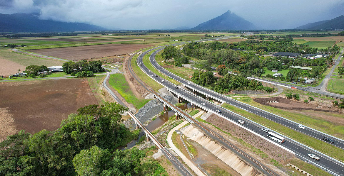
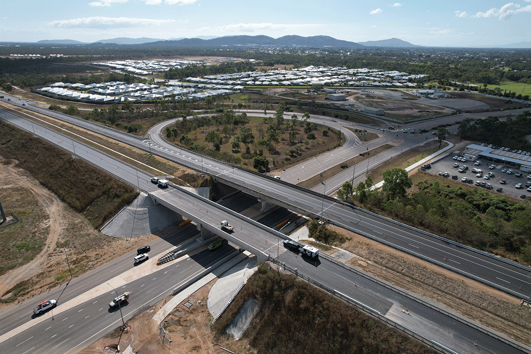
Major construction was completed for the Bruce Highway Upgrade — Caboolture-Bribie Island Road to Steve Irwin Way project in April 2024. This project widened the 11km stretch of the Bruce Highway from 4 to 6 lanes between Caboolture-Bribie Island Road and Steve Irwin Way (Exit 163). This also included upgrading creek crossings to improve flood immunity at Lagoon, King Johns, Six Mile, Un-named and Beerburrum Creeks.
The department has built a southbound overtaking lane and fauna crossing at Smiths Gap on the Bruce Highway.
Upgrades to improve flood immunity at Jumper Creek, between Mackay and Proserpine are now complete.
The Bruce Highway upgrade project at Goorganga Plains and Myrtle Creek, near Proserpine, aims to plan and preserve the road corridor to enhance flood immunity and address access issues during wet weather events.
Safety upgrades have been completed to almost 20km of the Bruce Highway from Proserpine to Bowen, as part of the Bruce Highway Upgrade Program.
The department has delivered a planning project to investigate and prioritise upgrades to the Bruce Highway between the Pine River and Caloundra Road.
A total transport solution has been delivered to provide long-term improvements to traffic flow and road safety through reducing congestion, highway travel time and improving road access.
The Bulimba Peninsula Transport and Congestion Study identified community priorities to improve transport options and outcomes for the Bulimba Peninsula.
In October 2007 Transport and Main Roads (then Queensland Transport) engaged GHD to undertake a study to identify a rail corridor (for freight traffic) to connect the Port of Bundaberg to the existing rail network via the North Coast line. The study report determined that protection of the corridor within the local government planning scheme was not warranted at the time, and the project was closed.
The future duplication of Caboolture-Bribie Island Road between King Johns Creek and Hickey Road will ease congestion and improve safety.
The department is undertaking detailed design for the duplication of Caboolture-Bribie Island Road between Old Toorbul Point Road and Saint Road, including signalisation of the Volz Road intersection.
The department is finalising a business case for the construction of a new bridge to Bribie Island.
The department has completed a comprehensive planning study into the 4 transport corridors linking Cairns to the Northern Tablelands.

3 high priority sections of the Capricorn Highway between Emerald and Alpha have been widened.

A pedestrian overpass over Elizabeth Avenue was installed to provide a safe crossing facility between Clontarf Beach State High School's main campus and Department of Education fields across the road.
Works were undertaken to upgrade the public boating facilities at Mission Beach Clump Point.
We have upgraded the park 'n' ride facilities at the Coomera train station.

A 3km section of aged, narrow pavement on the Cramsie-Muttaburra Road has been rehabilitated and widened, providing improved overtaking opportunities.

A major intersection upgrade to improve safety at the Cunningham and New England highways intersection is complete.

Eton Range fully opened to traffic on 1 October 2020. The existing range has been upgraded to 4 lanes, added a split carriageway for part of the range and reduced the grade to improve safety and efficiency.
Works have been completed to seal around 35km of the 185km road, improving safety, connectivity and wet weather access.
The department has delivered 9km of pavement strengthening and widening of the floodway along the Flinders Highway between Julia Creek and Cloncurry at Scrubby Creek.
The department has delivered 48km of new sealing along the Kennedy Developmental Road between The Lynd to Hughenden.
Intelligent Transport Systems (ITS) treatments on Kuranda Range Road have been installed. The Intelligent Transport System treatments will make it quicker and easier to manage incidents and reduce the risk of crashes.
The Six Mile Creek timber bridge on Kin Kin Road, 3km north of Pomona, has been replaced with a concrete bridge structure.
Construction is complete for safer pedestrian crossings in Maroochydore's entertainment precinct.

Rocky Creek Bridge was replaced to improve safety, traffic flow, flood immunity and efficiency.

Construction is complete to improve safety on Ruthven Street in Toowoomba's south.
This planning project involved investigating ways to improve safety and efficiency on the New England Highway between Hodgson Creek and the southern side of Cambooya Connection Road.

The department has delivered pavement widening and resurfacing works to improve safety and freight efficiency on the New England Highway between Stanthorpe and Ballandean.

The upgrade of the New England Highway between Cooyar and Bum Bum Creek has been completed, delivering critical safety and efficiency improvements south of Yarraman.
The department has completed planning which investigated expansion of parking facilities at Northgate station in response to high demand for parking in the local area.
We have upgraded the car park at the Ormeau station park 'n' ride.

The Sports Drive to Gateway Motorway Upgrade is part of a rolling program of upgrades between the Gateway and Logan Motorways.
Safety improvements to the Ormeau Interchange (Exit 45) southbound off-ramp on the Pacific Motorway has reduced traffic on the M1 and Lahrs Road.

We have delivered an upgrade of the M1 between Mudgeeraba and Varsity Lakes to reduce travel time and congestion, improve safety, and increase traffic flow. Interchange enhancements have improved access on and off the motorway.

Construction to upgrade the M1/M3 Gateway merge to improve safety and reduce peak hour congestion was completed in May 2020.

The Pacific Highway (western service road) in Slacks Creek was realigned and upgraded as part of the Pacific Motorway, Eight Mile Plains to Daisy Hill Upgrade.
The Yatala South (Exit 41) interchange upgrade on the Pacific Motorway (M1) has resulted in significant enhancements to safety and traffic flow in the area.

Another 3km of the road has been sealed to improve safety and travel times on this key transport link.
This project upgraded about 4km of Rockhampton-Emu Park Road to improve safety for all road users.
We conducted a multi-modal study of the ongoing and increasing transport pressures relating to road, active transport and public transport modes in Brisbane’s inner south.
The Southern Freight Rail Corridor has been identified as a future route connecting the Western Rail line near Rosewood to the interstate railway north of Beaudesert. The Southern Freight Rail Corridor will serve as a major freight link connecting a future Melbourne to Brisbane Inland Rail line with the existing south-east Queensland rail freight network.
Construction is complete for the upgrade of the Strathpine Shopping Centre bus station.
The Townsville Ring Road Stage 5 project, a landmark initiative that has brought about substantial improvements in road safety, traffic flow and travel time predictability for both freight and passenger vehicles along the Bruce Highway in Townsville, has been completed.

The O’Keefe Street velobridge at Woolloongabba is now open.

This project is part of a state-wide strategy to help improve bicycle riding facilities and networks in Warwick to increase active transport.
Last updated: 11 June 2024