Logan and Gold Coast Faster Rail

We're connecting our growing communities with more frequent and reliable train services between Brisbane, Logan and the Gold Coast.

South East Queensland (SEQ) has experienced significant growth over the last 2 decades. This growth is expected to continue with an extra 1.5 million people living in the region by 2036. To harness this growth and support our region's thriving communities we must keep evolving the rail network so that it plays a bigger role in moving people around SEQ.

To support our growing population and rail patronage demand between Brisbane, Logan and the Gold Coast, we need to double the number of Beenleigh and Gold Coast train services over the next 20 years.

The rail line between Kuraby and Beenleigh is a key capacity bottleneck on the network. Currently, trains between Kuraby and Beenleigh share a single track in each direction, limiting the number of peak services that can run. During peak periods, all-stop Beenleigh trains need to be held to one side to allow Gold Coast express trains to pass through. 

The Logan and Gold Coast Faster Rail project will address this problem by doubling the number of tracks between Kuraby and Beenleigh to allow the free movement of both all-stops and express trains. The project will also upgrade stations to improve accessibility, remove 5 level crossings, improve park ‘n’ ride facilities and provide a new continuous active travel path connecting to stations along the 20km section of upgraded tracks.

Key features

Logan and Gold Coast Faster Rail will deliver:

  • double the capacity of the Gold Coast rail line and reduce waiting times at stations between Brisbane, Logan and the Gold Coast
  • approximately 20km of new tracks and rail systems between Kuraby station and Beenleigh station, increasing the corridor from 2 to 4 tracks
  • better connected communities through accessible upgrades at stations and dedicated active transport facilities and paths along the corridor 
  • improved road network efficiency and reduced peak hour traffic congestion through intersection upgrades and level crossing removals at Kuraby, Woodridge, Bethania, Holmview, and Beenleigh
  • new train signalling technology between Salisbury and Varsity Lakes
  • extension of the cattle siding at Holmview.

Logan and Gold Coast Faster Rail flythrough video

Video Transcript
0:00:00.600-->0:00:03.712
The words Logan and Gold Coast Faster Rail appear on the screen, over a map of South East Queensland.

0:00:04.000-->0:00:10.640
Orange markers identify Kuraby station and Beenleigh station on the map.

0:00:10.640-->0:00:14.320
A dark blue line traces the existing rail line and the location of the Logan and Gold Coast Faster Rail project corridor.

0:00:14.320-->0:00:17.607
A light blue line extends north and south showing the Gold Coast rail line and Cross River Rail project.

0:00:17.607-->0:00:27.050
Green boxes then appear which show the location of Brisbane, Logan, and the Gold Coast in relation to the project.

0:00:27.417-->0:00:36.417
An aerial map appears with a line travelling south along the existing rail line.

0:00:39.000-->0:00:45.000
A marker for Kuraby station appears and green shading shows the project footprint along the rail line.

0:00:45.000-->0:00:48.000
Markers on the map pick out nearby Kuraby State School, Wally Tate Park, the Gateway Motorway, Beenleigh Road Park and Beenleigh Road.

0:00:48.000-->0:00:52.000
A concept design for Kuraby station, which is modern and coloured white and beige. There are covered areas for shade.

0:00:52.000-->0:00:54.000
The building is supported by V shaped pillars and there is a lift and steps to the platform.

0:00:55.000-->0:00:59.000
A marker for Trinder Park station appears on an aerial map showing the local area.

0:00:59.000-->0:01:01.520
Green shading highlights the project footprint in the surrounding area

0:01:01.520-->0:01:04.520
and markers showing the nearby park ‘n’ ride, road over rail bridge and level crossing closure at Trinder Crossing.

0:01:04.520-->0:01:06.520
Markers show Woodridge North State School, Logan Metro Football Club, Karawatha Forest Discovery Centre and Trinder Park current station in relation to the project.

0:01:06.520-->0:01:09.640
A concept design for Trinder Park station, which is modern and coloured white and beige. There is a covered area to the right.

0:01:09.640-->0:01:12.060
The roof is supported by V shaped pillars with steps to the platform.

0:01:12.060-->0:01:15.000
A marker for Woodridge station appears on an aerial map showing the local area.

0:01:15.000-->0:01:19.295
Green shading highlights the project footprint in the surrounding area and the new park ‘n’ ride.

0:01:19.295-->0:01:23.379
Markers show the location of Railway Parade, Wembley Road, Woodridge State School,

0:01:23.379-->0:01:26.052
Logan City Council and Jacaranda Avenue in relation to the project footprint.

0:01:26.052-->0:01:30.800
A concept design for the new widened underpass at Woodridge station which is light, bright, and modern.

0:01:30.920-->0:01:35.799
A marker for Kingston station appears on an aerial map showing the local area.

0:01:35.799-->0:01:38.947
Green shading now shows the project footprint around the station.

0:01:38.947-->0:01:41.924
Markers show nearby Collin Park, Kingston Road, Mary Street, Kingston Butter Factory and Gould Adams Park

0:01:42.000-->0:01:45.289
A concept design for Kingston station, which is modern and coloured white and beige. There is a covered area to the right.

0:01:45.289-->0:01:47.080
The roof is supported by V shaped pillars with steps to the platform.

0:01:47.080-->0:01:50.080
A marker for Loganlea station appears on an aerial map showing the local area.

0:01:50.080-->0:01:52.080
Green shading shows the project footprint around the station.

0:01:52.080-->0:01:59.828
Markers show nearby Meadowbrook Shopping Centre, Loganlea current station, Logan Hospital, TAFE Qld Loganlea campus and Loganlea High School

0:01:59.828-->0:02:02.480
A concept design for the new Loganlea station which is modern and coloured grey and beige. There are covered areas for shade.

0:02:02.480-->0:02:05.000
The building is supported by vertical pillars with steps to the platform.

0:02:05.000-->0:02:07.000
A marker for Bethania station appears on an aerial map showing the local area.

0:02:07.000-->0:02:12.000
Green shading shows the project footprint around the station and the new park ‘n’ ride.

0:02:12.000-->0:02:17.480
Markers show nearby Bethania Aquatic Centre, Bethania Waters Shopping Centre, Station Road, Holzheimer Road and Bethania Lutheran Church.

0:02:17.480-->0:02:21.480
A concept design for the new Bethania station which is modern and coloured white and beige. There are covered areas to the right.

0:02:21.480-->0:02:23.240
The roof is supported by V shaped pillars with steps to the platform.

0:02:23.240-->0:02:27.240
A marker for Edens Landing station appears on an aerial map showing the local area.

0:02:27.240-->0:02:30.000
Green shading shows the project footprint.

0:02:30.000-->0:02:34.802
Markers show nearby Edens Landing Shopping Centre, Logan City Hawks Rugby Leagues Club and Edens Parkland.

0:02:34.802-->0:02:38.588
A concept design for the new Edens Landing station which is modern and coloured white and beige. There are covered areas for shade.

0:02:38.588-->0:02:40.680
The building is supported by V shaped pillars with steps to the platform.

0:02:40.680-->0:02:44.880
A marker for Holmview station appears on an aerial map showing the local area.

0:02:44.880-->0:02:47.880
Green shading shows the project footprint including the level crossing closure at Holmview

0:02:47.880-->0:02:50.880
road, the new park ‘n’ ride and the level crossing closure at Spanns Road.

0:02:50.880-->0:02:53.880
Markers show nearby Holmview Park, Holmview Road, the current Holmview station and Spanns Road level crossing.

0:02:53.880-->0:02:56.772
A concept design for the new Holmview station which is modern and coloured white and beige. There are covered areas for shade.

0:02:56.772-->0:02:58.760
The building is supported by V shaped pillars with steps to the platform.

0:02:58.760-->0:03:02.000
A marker for Beenleigh station appears on an aerial map showing the local area.

0:03:02.000-->0:03:04.000
Green shading shows the project footprint including the park ‘n’ ride.

0:03:04.000-->0:03:06.000
Markers show nearby Hammel Park Sporting Facilities, James Street, Beenleigh State School, Beenleigh Library,

0:03:06.000-->0:03:08.000
Beenleigh Town Square, George Street, the current Beenleigh station and the Beenleigh Marketplace.

0:03:13.400-->0:03:15.400
A concept design for the new Beenleigh station which is modern and coloured white and beige. There are covered areas for shade and a multi-story carpark.

0:03:15.400-->0:03:18.400
The building is supported by V shaped pillars. Lifts and stairs lead to the platforms.

0:03:18.400-->0:03:24.400
An aerial map shows the route of the rail line and stations included in the project.

0:03:24.400-->0:03:28.400
The words Logan and Gold Coast Faster Rail appear on the screen along with the Australian Government logo and the Queensland Government logo.
 

Benefits

  • Improves network efficiency
  • Improves safety
  • Better road access
  • Reduces travel time
  • Contributes to regional growth
  • Increases capacity
  • Reduces peak hour congestion
  • Increases car parks
  • Contributes to economy
  • Better active transport

Funding

The Australian Government and Queensland Government are funding the project. Investment ID 2008163.

Funding figures updated December 2023 to reflect increased Australian Government and Queensland Government contributions.

Total investment
$5.75 billion
Australian Government
$2.875 billion
Queensland Government
$2.875 billion

Current status

In late 2023, we completed community engagement on the refined reference design for the project, as well as the detailed design for the Loganlea Station Relocation project.

The Contractor procurement process is progressing and in March 2024 we shortlisted parties to tender for the delivery of three packages of work:

Logan and Gold Coast Rail Package – will deliver the major rail works between Kuraby and Beenleigh including doubling the number tracks from two to four, station upgrades, three level crossing removals (at Woodridge, Holmview and Beenleigh), local road works and active transport connections.

Logan and Gold Coast Open Level Crossing Removals Package – will remove two level crossings at Beenleigh Road, Kuraby and Station Road, Bethania and replace with new road-over-rail bridges, improving safety and journey times for road and rail users.

Loganlea Station Relocation Project – will upgrade and relocate Loganlea station to better connect customers with nearby education, community and health services – particularly Logan Hospital.

We expect to award contracts in late 2024, subject to government approvals.

Construction timeframes will be confirmed once contractors have been appointed.

Field investigations

You might notice some field investigations being conducted at selected sites throughout the corridor. This information will help us understand more about the existing conditions and environment along the rail corridor.

If we need access to private property, we will contact the owners in advance to make suitable arrangements.

Project timeline

  • September to October 2021: Community engagement on business case
  • 2022–2023: Further refinement of the reference design
  • August 2023: Procurement activities started
  • November to December 2023: Community engagement on refined reference design
  • March 2024: Potential contractors shortlisted
  • Late 2024: Expected contract awarded
  • 2025: Expected start of construction

Additional information

Information for property owners

Property owners who have been informed they are directly impacted by this project may be eligible to apply for a strategic purchase of their property. A strategic purchase allows owners to voluntarily apply to sell their property to the department before the formal resumption process.

While there is no difference between the compensation assessment process of a strategic purchase and compulsory acquisition, a strategic purchase can provide property owners with more flexibility in the timing of the sale.

If you have been advised that your property is directly impacted by the project, you may be eligible to apply for a strategic purchase. Contact the project team to understand your eligibility and to apply.

We want to ensure that people interested in buying property in the area are also aware of the project. A Transport and Main Roads property search will show if there is a property requirement for the land. Potential owners can contact the project team with any questions.

Information for local business owners

We've been visiting local businesses along the project corridor to provide an update on the project and to gather information and feedback to inform future planning. 

Local business owners are encouraged to register their details with us by contacting the project team on 1800 957 066 or by emailing LGC.Business@tmr.qld.gov.au.

Logan and Gold Coast Faster Rail location map

Map details the train line from Beenleigh to Kuraby
The project is located along the rail corridor from Kuraby station to Beenleigh station. In the background both the road network and the Logan River are shown. The map identifies the alignment of the tracks and shows stations including (from north to south) Kuraby, Trinder Park, Woodridge, Kingston, Loganlea, Bethania, Edens Landing, Holmview and Beenleigh. The track alignment shows the curved section of track at the existing Trinder Park station location and where the new section of straightened track will run in its place. The map also shows the locations of five level crossings that will be removed as part of the project. These are located at Kuraby, Woodridge, Bethania and Holmview station in Beenleigh.

38 Projects in Logan and Gold Coast Faster Rail

Artist impression of Beenleigh Train station showing carpark, pedestrian overpass and lift and stair access.

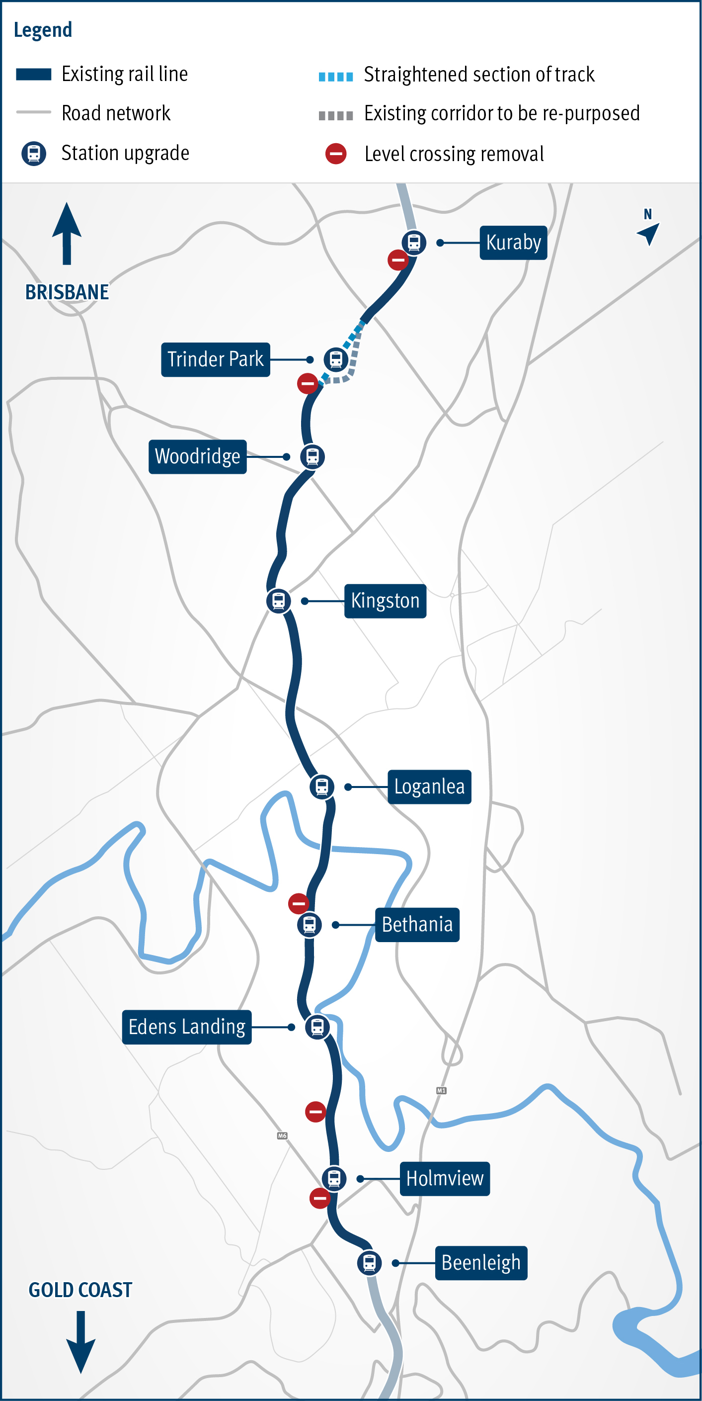
Beenleigh train station upgrade

Beenleigh train station is a key transfer location between all-stops and express services on the Beenleigh and Gold Coast train lines.

 The North Coast Line meanders through the Glass House Mountains

Beerburrum to Nambour Rail Upgrade (Stage 1)

The Beerburrum to Nambour Rail Upgrade will provide additional track capacity and reliability, creating travel time savings and increased passenger and freight services to the growing Sunshine Coast region.

Artist impression of the Bethania train station from street view.

Bethania train station upgrade

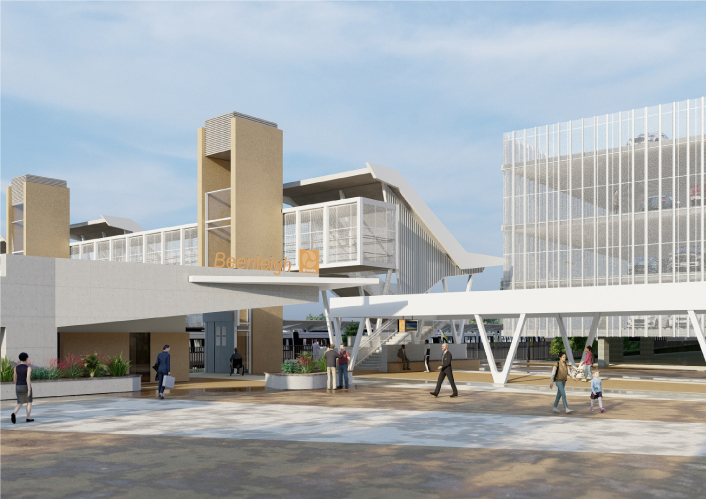
Bethania train station is being upgraded to improve accessibility, safety and customer experience. 

The map shows the locality of the proposed Booral Road and Boundary Road intersection upgrade. Hervey Bay is located north-east of the project location. A solid blue line indicates the project extent, which encompasses the Booral Road and Boundary Road intersection, and also extends along Booral Road to the north past the Emerald Park Way intersection and to the south along Booral Road past the proposed new Walkers Road intersection. Walkers Road has been realigned to access Booral Road to the south of the Booral Road and Boundary Road intersection. The local road network, including where Booral Road turns into Elizabeth Street, is also highlighted on the map.

Booral Road and Boundary Road (Urangan), intersection upgrade

Detailed design is underway for a proposed upgrade of the Booral Road and Boundary Road intersection at Urangan.

Boundary Road Coopers Plains Rail Crossing map

Boundary Road (Coopers Plains), rail level crossing, funding commitment

A preferred option has been identified to reduce congestion and address safety concerns at Boundary Road, Coopers Plains rail level crossing.

No image supplied

Bruce Highway (Gympie – Maryborough), Tiaro Bypass, construct four lane bypass

Planning is complete and the detailed design stage has commenced for a new four-lane section of the Bruce Highway to the east of Tiaro. The project will increase the flood immunity, safety and efficiency of the Bruce Highway and future-proof the road to cater for growing traffic volumes. It will also remove a significant number of heavy vehicles from the Tiaro township, improving safety and liveability for residents.

Hickey Road

Caboolture-Bribie Island Road, Hickey Road to King Johns Creek

The future duplication of Caboolture-Bribie Island Road between King Johns Creek and Hickey Road will ease congestion and improve safety.

Side of Old Toorbul Point Road

Caboolture-Bribie Island Road, Old Toorbul Point Road to Saint Road

The department is undertaking detailed design for the duplication of Caboolture-Bribie Island Road between Old Toorbul Point Road and Saint Road, including signalisation of the Volz Road intersection.

Cairns Western Arterial Road, Redlynch Connector Road to Captain Cook Highway, duplication

The department is undertaking a $300 million project to duplicate the Cairns Western Arterial Road between Redlynch Connector Road and Captain Cook Highway.

No image supplied

Cannon Hill Shopping Centre bus facility, design bus station

The Cannon Hill Shopping Centre bus facility is proposed to be upgraded.

No image supplied

Centenary Motorway (Yamanto – Ellen Grove) and Springfield Greenbank Arterial exit ramp, upgrade intersection

The department is working with Ipswich City Council to upgrade the Centenary Motorway exit ramp (Exit 32), and the Main Street and Springfield Greenbank Arterial Road intersection, to manage congestion and improve safety at the exit ramp.

No image supplied

Coomera Connector Stage 1 Central

Coomera Connector (Stage 1) is around 16km long and will be delivered in 3 construction packages. Stage 1 Central, which is currently in the design phase, is the 8km section from Helensvale Road to Smith Street Motorway.

No image supplied

Coomera Connector Stage 1 South

Design phase is underway for the Coomera Connector Stage 1 South package from Smith Street Motorway to Nerang-Broadbeach Road.

No image supplied

Coominya Connection Road, Buaraba Creek, replace timber bridge

The Buaraba Creek timber bridge replacement project will improve safety and network reliability by replacing the existing narrow, timber bridge (Neithe Bridge) with a new wider, two-lane, concrete structure in the same location.

No image supplied

Cunningham Highway (Ipswich – Warwick), Tregony to Maryvale, improve safety and Cunningham Highway (Ipswich – Warwick), various locations, improve safety

The project involves investigating safety improvements to provide a better driving experience for all road users and reduce the risk of fatal and serious injury crashes.

No image supplied

Cunningham Highway (Warwick – Inglewood), improve safety

This project involves investigating safety improvements to provide a better driving experience for all road users and reduce the risk of fatal and serious injury crashes.

No image supplied

David Low Way cycle facility

On-road bicycle lanes are being constructed to improve safety at Marcoola and Mudjimba.

Artist impression of Edens Landing train station from street view showing the street level access with pedestrian bridge.

Edens Landing train station upgrade

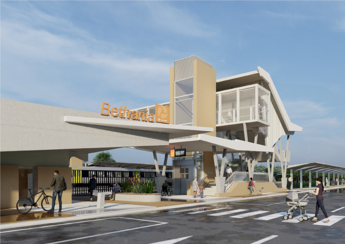
Edens Landing station is being upgraded to improve accessibility, safety and customer experience.

Thumbnail of map showing the proposed expansion of parking facilities at Gaythorne train station park 'n' ride

Gaythorne train station park 'n' ride, design and land acquisition

Detailed design has started for future expansion of parking facilities at Gaythorne station.

No image supplied

Glass House Mountains Road (Steve Irwin Way) and Caloundra Street intersection upgrade

The department will deliver a new signalised intersection on Glass House Mountains Road, known locally as Steve Irwin Way, at Caloundra Street, Landsborough.

No image supplied

Gympie – Brooloo Road, design active transport crossings

Detailed design is underway for active transport bridges and pathways to connect Southside to Gympie's CBD and surrounds.

Artist impression of the Holmview train station from street view looking at the new station entrance.

Holmview train station upgrade

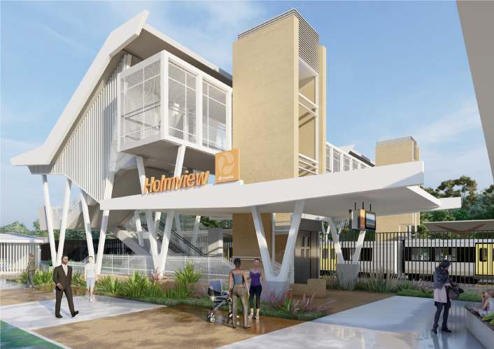
Holmview train station is being upgraded to improve accessibility, safety and customer experience.

Artist impression of the Kingston train station entrance at street level.

Kingston train station upgrade

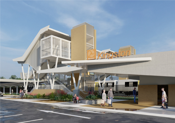
Kingston train station is being upgraded to improve accessibility, safety and customer experience for the community. 

Artist impression of how the upgraded Kuraby train station will look. The image shows the the new Kuraby entrance from street view with a train pulled into the station.

Kuraby train station upgrade

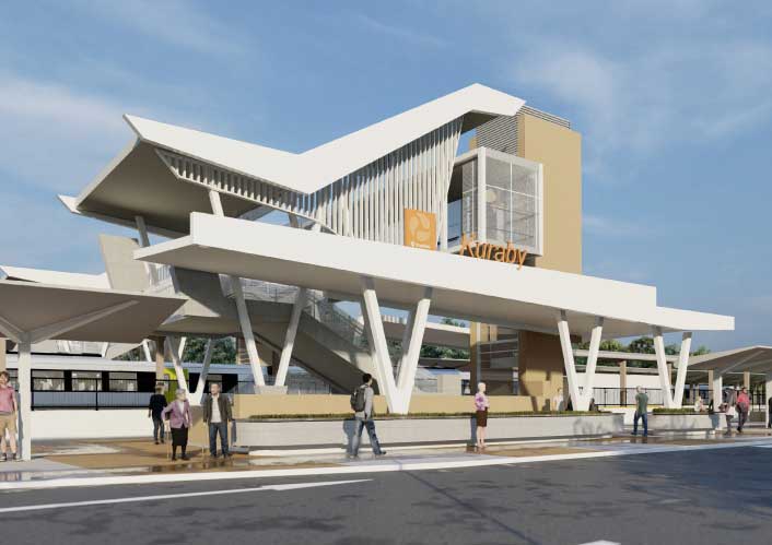
Kuraby station is being upgraded to improve accessibility, safety and customer experience for the community. 

Artist impression of the proposed upgraded Loganlea station. Image is looking from Station Road and shows the new wider underpass with people out the front of the new station building and trains pulled up at the platforms.

Loganlea train station and park 'n' ride relocation

We are relocating Loganlea train station and the park 'n' ride closer to Logan Hospital.

No image supplied

Maryborough - Hervey Bay Road and Pialba - Burrum Heads Road, upgrade intersection

The upgrade of the Maryborough - Hervey Bay Road and Pialba - Burrum Heads Road intersection in Eli Waters will improve traffic movement and the safety of motorists, pedestrians and bicycle riders.

Map showing the proposed alignment for Mooloolaba to Maroochydore Cycleway

Mooloolaba to Maroochydore cycleway, design cycleway

The department is partnering with Sunshine Coast Council to deliver the Mooloolaba to Maroochydore cycleway which will provide a bicycle path connecting Mooloolaba to Maroochydore.

Nicklin Way looking south towards Caloundra at the location where Third Avenue will connect 1

Nicklin Way, Third Avenue extension, new intersection

An ultimate project footprint has been identified for the Caloundra Transport Corridor Upgrade, including the Nicklin Way, Third Avenue extension.

An aerial view of the Pacific Motorway Eight Mile Plains to Daisy Hill upgrade project.

Pacific Motorway, Eight Mile Plains to Daisy Hill Upgrade

Work is being undertaken on the Pacific Motorway, Eight Mile Plains to Daisy Hill Upgrade, to improve 8kms of the Pacific Motorway (M1) between the Gateway Motorway and Watland Street.

Pialba–Burrum Heads Road, O’Regan Creek, upgrade existing floodway project location map

Pialba–Burrum Heads Road, O’Regan Creek, upgrade existing floodway

This upgrade will improve flood resilience for Hervey Bay and surrounding communities and involves pavement realignment, widening and culvert upgrades.

No image supplied

Proserpine - Shute Harbour Road, Paluma Road to Tropic Road (Cannonvale), duplication

An upgrade is being delivered to a 1.5km section of Proserpine-Shute Harbour Road in Cannonvale.

Proserpine – Shute Harbour Road, Hamilton Plains, flood immunity upgrade

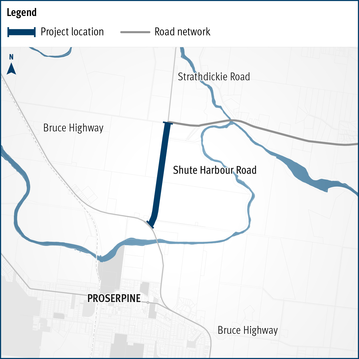
A flood immunity upgrade will be delivered to a 1.5km section of Proserpine – Shute Harbour Road at Hamilton Plains between the Bruce Highway turn-off and Strathdickie Road.

Sunshine Motorway, Mooloolah River Interchange Upgrade (Stage 1)

The Sunshine Motorway, Mooloolah River Interchange Upgrade will address well-known safety and congestion issues that are forecast to increase due to regional population growth and development, while also delivering improved north-south connectivity on the Sunshine Coast.

No image supplied

The Burke Developmental Road (Normanton – Dimbulah), flood resilience projects

More than $16 million is committed to improve flood resilience across Gulf communities after monsoonal flooding produced widespread impacts across the northern 2-thirds of Queensland in early 2023.

No image supplied

Toowoomba–Cecil Plains Road, improve safety

Detailed design commenced in October 2023 and is expected to be completed in June 2024.

Artist impression of proposed new Trinder Park station with the Translink logo and Trinder Park sign on the front. Image is looking from Alexander Street with people out the front of the new station building and a train pulled up at a platform.

Trinder Park train station upgrade

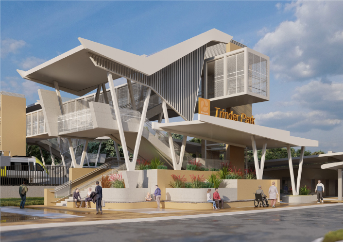
Trinder Park train station is being relocated further north to be more centrally located between the Kuraby and Woodridge train stations. The relocation will improve safety and network efficiency due to its new straightened section of the track.

Warrego Highway Mount Crosby upgrade project area aerial image

Warrego Highway (Ipswich - Toowoomba) and Mount Crosby Road interchange, detailed design

The department has completed planning to identify a preferred option for the upgrade of Warrego Highway – Mount Crosby Road interchange.

Artist impression of the proposed upgraded Woodridge station with the Translink logo and Woodridge sign on the front. Image is looking from Station Road and shows the new wider underpass with people out the front of the new station building and trains pulled up at the platforms.

Woodridge train station upgrade

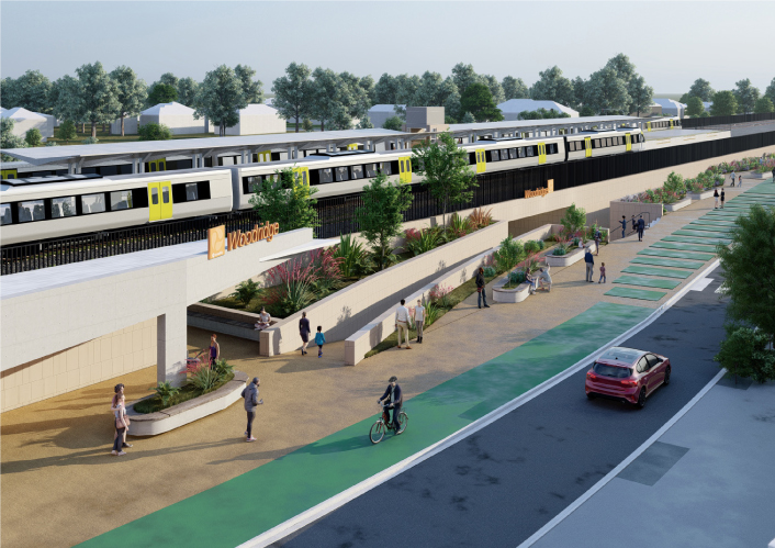
Woodridge station is being upgraded to improve accessibility, safety and customer experience.