Natural Disaster Program

The department is working on more than 920 projects to restore roads across Queensland damaged by floods and bushfires. The department is also reconnecting communities and supporting regional economic recovery after disaster events damaged the state-controlled road network in 2020, 2021, 2022, 2023 and 2024.

Key features

  • Restoring access for communities and businesses. 
  • Restoring damaged roads and road surfaces.
  • Repairing damaged structures, including bridges and culverts.
  • Repairing damaged slopes and batters along roads.
  • Clearing silt and debris.

Benefits

  • Restores damaged infrastructure
  • Contributes to economy
  • Contributes to regional growth

About the program.

  • The Natural Disaster Program reconnects Queenslanders by repairing parts of the state-controlled road network damaged by natural disasters.
  • The department restores damaged sites to their pre-disaster level of service.
  • In the first 3 months after disaster events, the department undertakes emergency works such as clearing debris and filling potholes. This enables roads to be used safely while the department completes geotechnical and environmental investigations, surveys and detailed design for reconstruction works, where required.
  • Reconstruction works are completed within 2 financial years after the financial year in which the disaster event occurred.
  • Where possible, the program also supports the resilience of state roads to future disasters.

Current status

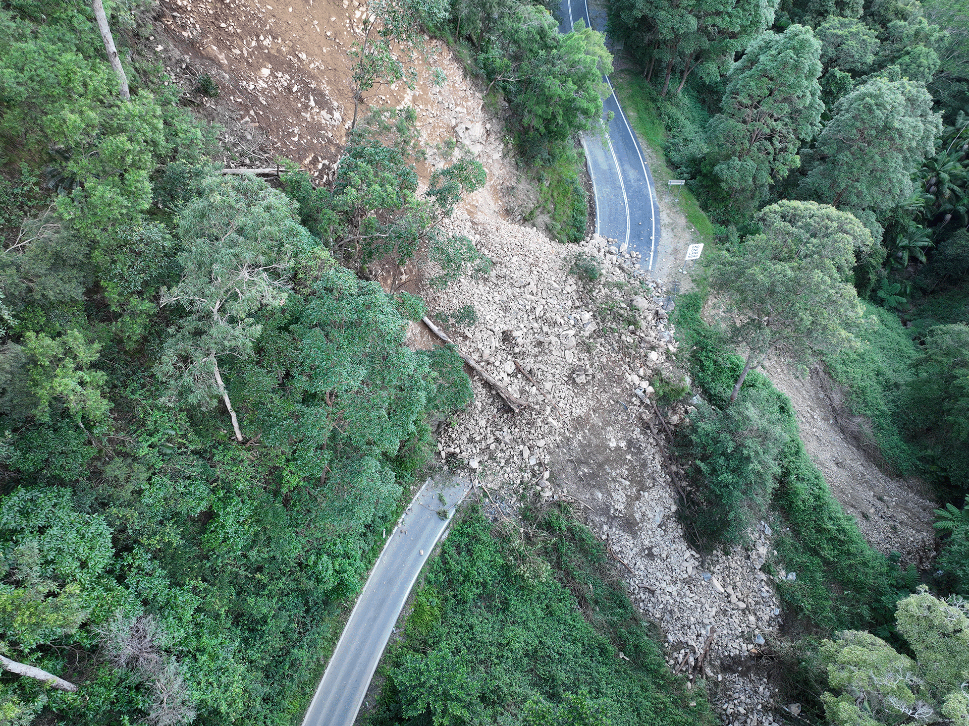
  • Damage assessments and repairs are underway across Queensland after significant disaster events in 2023–24. Tropical Cyclone Jasper caused multiple landslips on range roads around Cairns, a major debris clean-up is ongoing following severe storms across southern Queensland and flooding associated with Tropical Cyclone Kirrily damaged roads in western Queensland.
  • Repairs are ongoing after flooding across northern and central Queensland in early 2023.
  • A substantial recovery program is underway, particularly across southern Queensland, after major disaster events caused extensive damage in 2021–22. The program is repairing significant state road damage across 41 local government areas, including numerous major landslips, widespread pavement damage and shoulder scouring and widespread scouring around culverts and bridges.
  • Repairs are nearing completion in the Gold Coast hinterland following heavy rainfall and flooding in December 2020 and March 2021.
  • Reconstruction works are underway on the Cunningham Highway where bushfires caused significant slope damage at Cunninghams Gap in late 2019. Due to the severe damage and complex site, repairs are being undertaken over an extended period.
Funding

The recovery works are jointly funded by the Australian and Queensland Governments through the Disaster Recovery Funding Arrangements (DRFA).

Traffic info

These works may change traffic conditions that impact your travel. Visit QLDTraffic to plan your journey.

58 Projects in Natural Disaster Program

Photograph of the Beaudesert-Nerang Road and Tabragalba House Road intersection

Beaudesert to Beenleigh corridor safety improvements

The department has delivered safety improvements on sections of the Beaudesert to Beenleigh corridor.

No image supplied

Beaudesert–Beenleigh Road, Milne Street to Tallagandra Road, duplicate to four lanes

This project will see the road duplicated between Mount Warren Boulevard and Tallagandra Road.

No image supplied

Beenleigh Connection Road (Logan Street) and City Road, intersection upgrade

The department is planning for a future upgrade of the intersection of Beenleigh Connection Road (Logan Street) and City Road.

Artist impression of Beenleigh Train station showing carpark, pedestrian overpass and lift and stair access.

Beenleigh train station upgrade

Beenleigh train station is a key transfer location between all-stops and express services on the Beenleigh and Gold Coast train lines.

No image supplied

Beenleigh–Redland Bay Road, Logandale Boulevard to Mount Cotton Road upgrade, planning

Planning will be undertaken for the section of the road between Logandale Boulevard and Mount Cotton Road.

Artist impression of the Bethania train station from street view.

Bethania train station upgrade

Bethania train station is being upgraded to improve accessibility, safety and customer experience. 

Map showing safety improvement works located at the intersection of Camp Cable Road and Edelsten Road in Jimboomba. The northern side of Camp Cable Road will be widened to allow for a dedicated right turn lane into Edlesten Road, so motorists can safely wait before turning, and through-traffic can continue ahead towards Yarrabilba. Camp Cable Road will have new formalised bus stops on both sides of the road along with an extra 2 metres of shoulder width for bicycle riders.  The existing left turn lane from Camp Cable Road onto Edelsten Road will be relinemarked as a shared left turn lane to improve traffic flow. New Stop signs will be installed on Edelsten Road at the intersection replacing the existing Give Way signs.

Camp Cable Road and Edelsten Road, improve intersection

This intersection is identified for an upgrade due to the rapid expansion of local urban areas, increased traffic volumes and crash history.

No image supplied

Central Gold Coast East-West Passenger Transport Study

Together with the Gold Coast City Council, we are working on the Central Gold Coast East-West Passenger Transport Study.

Coomera Connector Future stages Foxwell street - October 2023

Coomera Connector (Future stages) Loganholme to Coomera, planning

Planning is underway for the future stages of the Coomera Connector – the remaining 29km between Loganholme and Coomera.

Artist's impression of a road crossing a river

Coomera Connector (Stage 1)

The Stage 1 section of the Coomera Connector between Coomera and Nerang has been identified as the priority section to be built first.

Coomera train station, upgrade park 'n' ride

We have upgraded the park 'n' ride facilities at the Coomera train station.

Aerial image of Cunningham Highway at Cunninghams Gap

Cunningham Highway (Ipswich – Warwick), 2020 Disaster Recovery Funding Arrangements reconstruction works

The department is committed to restoring and repairing the damaged section of the Cunningham Highway at Cunninghams Gap. This 2km stretch, leading up to the Allan Cunningham monument, suffered significant road damage during the bushfires in 2019.

No image supplied

Cunningham Highway Upgrade

Planning is underway to upgrade the Cunningham Highway.

No image supplied

Currumbin Creek Road – Bienvenue Drive intersection upgrade

The intersection of Currumbin Creek Road and Bienvenue Drive, at Currumbin Waters will be upgraded.

Artist impression of Edens Landing train station from street view showing the street level access with pedestrian bridge.

Edens Landing train station upgrade

Edens Landing station is being upgraded to improve accessibility, safety and customer experience.

Flood resilience works

The department is improving the flood immunity and resilience of the state-controlled road network at 27 priority sites.

No image supplied

Gold Coast Heavy Rail Extension – Varsity Lakes to Gold Coast Airport

We are continuing to protect and plan for the Gold Coast heavy rail corridor between Varsity Lakes and Gold Coast Airport.

No image supplied

Gold Coast Highway (Broadbeach to Coolangatta) Currumbin Creek Cycleway, planning

Planning has started on the proposed Currumbin Creek Active Transport Bridge between Palm Beach and Currumbin.

No image supplied

Gold Coast Highway (Helensvale - Southport), Pine Ridge Road and Captain Cook Drive, intersection

The department is undertaking planning for future upgrades to the Gold Coast Highway at the intersection of Captain Cook Drive/Pine Ridge Road due to the high volume of traffic causing congestion and delays. The future upgrade aims to improve traffic flow and safety at the intersection

Gold Coast Light Rail Tram with 'Burleigh' destination

Gold Coast Light Rail (Stage 3) Broadbeach South to Burleigh Heads, construct light rail

Gold Coast Light Rail is a world class public transport system for residents and visitors to the Gold Coast.

No image supplied

Gold Coast Light Rail Stage 4

The proposed Gold Coast Light Rail Stage 4 is a world class public transport system for residents and visitors to the Gold Coast.

No image supplied

Gold Coast Springbrook Road Mudgeeraba Creek Causeway upgrade

We are planning for a future upgrade of the Mudgeeraba Creek Causeway on Gold Coast–Springbrook Road, Austinville.

Aerial view of Gold Coast-Springbrook Road major slip site

Gold Coast-Springbrook Road, Disaster Recovery Funding Arrangements reconstruction works

Gold Coast-Springbrook sustained a significant number of landslips, rock falls and tree falls over a 10-kilometre section during extreme rainfall and flooding events from 22 February to 20 May 2022.

Artist impression of the Holmview train station from street view looking at the new station entrance.

Holmview train station upgrade

Holmview train station is being upgraded to improve accessibility, safety and customer experience.

Artist impression of the Kingston train station entrance at street level.

Kingston train station upgrade

Kingston train station is being upgraded to improve accessibility, safety and customer experience for the community. 

No image supplied

Labrador – Carrara Road, Gold Coast Highway to Napper Road, construct cycleway

Design is underway for a bikeway on Olsen Avenue between the Gold Coast Highway and Napper Road.

Aerial photograph of a major landslip on Lamington National Park Road

Lamington National Park Road, Disaster Recovery Funding Arrangements reconstruction works

The department is working on multiple locations along Lamington National Park Road which require pavement rehabilitation and permanent reconstruction work following record rainfall across south east Queensland since December 2020.

Artist impression of the proposed upgraded Loganlea station. Image is looking from Station Road and shows the new wider underpass with people out the front of the new station building and trains pulled up at the platforms.

Loganlea train station and park 'n' ride relocation

We are relocating Loganlea train station and the park 'n' ride closer to Logan Hospital.

No image supplied

Nerang-Murwillumbah Road, safety treatments

This project is focused on improving safety along various sections of this 36km road where there is a high crash history. 

Artist's impression of the Ormeau rail facility

Ormeau rail facility

A rail facility is being constructed on a 66ha site in the Gold Coast region.

No image supplied

Ormeau station park 'n' ride upgrade

We have upgraded the car park at the Ormeau station park 'n' ride.

Aerial view of Pacific Motorway through Springwood

Pacific Motorway (M1) – Daisy Hill to Logan Motorway upgrade

Planning is underway for the Pacific Motorway (M1) – Daisy Hill to Logan Motorway upgrade. This section of the M1 cannot accommodate current traffic volumes and, as a result, experiences frequent and prolonged periods of congestion and poor travel time reliability.

Aerial of Pacific Motorway looking southbound at Eight Mile Plains

Pacific Motorway Eight Mile Plains to Daisy Hill Upgrade (Sports Drive to Gateway Motorway Upgrade)

The Sports Drive to Gateway Motorway Upgrade is part of a rolling program of upgrades between the Gateway and Logan Motorways.

An aerial view of the Pacific Motorway Eight Mile Plains to Daisy Hill upgrade project.

Pacific Motorway Eight Mile Plains to Daisy Hill Upgrade (Watland Street to Sports Drive Upgrade)

The Pacific Motorway (M1) between Watland Street and Sports Drive is being upgraded as part of a rolling program of upgrades between the Gateway and Logan Motorways.

No image supplied

Pacific Motorway Exit 45 southbound off-ramp, upgrade interchange

Safety improvements to the Ormeau Interchange (Exit 45) southbound off-ramp on the Pacific Motorway has reduced traffic on the M1 and Lahrs Road.

Pacific Motorway M1 Burleigh to Palm Beach Nineteenth Avenue Exit 89 Tallebudgera interchange

Pacific Motorway M1 Burleigh to Palm Beach (Nineteenth Avenue)

The M1 between Burleigh and Palm Beach (Package B) is being upgraded as part of the Varsity Lakes to Tugun (VL2T) upgrade. Package B will include significant environmental features through this section of the upgrade.

No image supplied

Pacific Motorway M1 Interchange upgrades

Planning and construction is underway for short and long-term upgrades of various interchanges on the Pacific Motorway (M1)

Pacific Motorway M1 Mudgeeraba to Varsity Lakes upgrade Mudgeeraba Creek bridges

Pacific Motorway M1 Mudgeeraba to Varsity Lakes upgrade

We have delivered an upgrade of the M1 between Mudgeeraba and Varsity Lakes to reduce travel time and congestion, improve safety, and increase traffic flow. Interchange enhancements have improved access on and off the motorway.

Pacific Motorway M1 Palm Beach Nineteenth Avenue to Tugun Currumbin Creek bridge

Pacific Motorway M1 Palm Beach (Nineteenth Avenue) to Tugun

The Pacific Motorway (M1) is being upgraded between Palm Beach and Tugun (Package C) as part of the Varsity Lakes to Tugun (VL2T) upgrade.

Image caption: Construction work in progress to upgrade the Burleigh Interchange to a Diverging Diamond Interchange at Exit 87.

Pacific Motorway M1 Varsity Lakes to Burleigh

The Pacific Motorway (M1) Varsity Lakes to Tugun (VL2T) is being upgraded and delivered in packages.

Aerial view of M1 at Varsity Lakes and Tugun section

Pacific Motorway M1 Varsity Lakes to Tugun upgrade

The $1.5 billion Pacific Motorway Varsity Lakes to Tugun (VL2T) project is being delivered to upgrade 10km of the M1 and is being constructing in packages to ensure faster delivery and best value for money.

M1 M3 Gateway merge

Pacific Motorway Upgrade M1 M3 Gateway merge

Construction to upgrade the M1/M3 Gateway merge to improve safety and reduce peak hour congestion was completed in May 2020.

An aerial view of the Pacific Motorway Eight Mile Plains to Daisy Hill upgrade project.

Pacific Motorway, Eight Mile Plains to Daisy Hill Upgrade

Work is being undertaken on the Pacific Motorway, Eight Mile Plains to Daisy Hill Upgrade, to improve 8kms of the Pacific Motorway (M1) between the Gateway Motorway and Watland Street.

Aerial photo of Pacific Highway early works location

Pacific Motorway, Eight Mile Plains to Daisy Hill Upgrade (Pacific Highway early works upgrade)

The Pacific Highway (western service road) in Slacks Creek was realigned and upgraded as part of the Pacific Motorway, Eight Mile Plains to Daisy Hill Upgrade.

Rochedale bus station and park n ride

Pacific Motorway, Eight Mile Plains to Daisy Hill Upgrade (Rochedale bus station and park 'n' ride)

As part of a rolling program of Pacific Motorway (M1) upgrades, detailed design for the Rochedale bus station and park 'n' ride is now complete.

No image supplied

Pacific Motorway, Exit 41, upgrade interchange

The Yatala South (Exit 41) interchange upgrade on the Pacific Motorway (M1) has resulted in significant enhancements to safety and traffic flow in the area.

No image supplied

Pacific Motorway, Exit 49, upgrade interchange

The Exit 49 interchange upgrade will deliver significant improvements in safety and traffic flow efficiency by keeping traffic moving through the improved interchange and thereby reducing queuing.

No image supplied

Park Ridge Connector

We are preserving the Park Ridge Connector, a future transport corridor to connect communities planned at Park Ridge, Flagstone and Yarrabilba to services and employment.

No image supplied

Road Asset Management Contract and Responsive Maintenance Contract—South Coast

We are delivering continual maintenance and rehabilitation of state-controlled roads and assets in the South Coast region.

No image supplied

Salisbury to Beaudesert Rail Business Case

We are planning for a proposed passenger rail line between Salisbury and Beaudesert.

An unpaved road between a mountain and bollards

South Coast 2020–21 flood reconstruction works

Reconstruction works are underway across the South East Region, including the Gold Coast and Scenic Rim, to repair storm damaged roads.

Landslip on Gold Coast - Springbrook Road

Southern Queensland 2022 flood reconstruction works

Repairs are underway across southern Queensland after extensive and severe damage to the state-controlled road network was caused by multiple heavy rainfall and flooding events in 2022.

No image supplied

Tallebudgera Connection Road Koala Zone Trial

The department values the protection of native fauna and supports koala protection treatments and initiatives to help mitigate koala-vehicle collisions.

Artist impression of proposed new Trinder Park station with the Translink logo and Trinder Park sign on the front. Image is looking from Alexander Street with people out the front of the new station building and a train pulled up at a platform.

Trinder Park train station upgrade

Trinder Park train station is being relocated further north to be more centrally located between the Kuraby and Woodridge train stations. The relocation will improve safety and network efficiency due to its new straightened section of the track.

No image supplied

Varsity Lakes train station park 'n' ride upgrade

The Varsity Lakes station park 'n' ride upgrade is delivering close to 350 parking spaces.

No image supplied

Waterford–Tamborine Road

Waterford-Tamborine Road is being upgraded in stages.

Artist impression of the proposed upgraded Woodridge station with the Translink logo and Woodridge sign on the front. Image is looking from Station Road and shows the new wider underpass with people out the front of the new station building and trains pulled up at the platforms.

Woodridge train station upgrade

Woodridge station is being upgraded to improve accessibility, safety and customer experience.