
Access to Gladstone Port project
We are progressing a project to provide an alternate route for heavy vehicles accessing the Port of Gladstone to increase freight efficiency and improve safety for local motorists.
Accelerated funding has been allocated through the following Road Stimulus Packages to increase investment in roads and transport infrastructure as part of The Queensland Economic Recovery Strategy.
Together with the Australian Government, we are improving Queensland's inland freight corridors by investing $185 million across 22 projects. The Roads of Strategic Importance early works package projects are jointly funded by the Australian and Queensland Governments.
These projects will help the freight and logistic industry move essential goods throughout Queensland more efficiently while protecting the safety of all road users.
Project works include:
View details of all jointly-funded Roads of Strategic Importance early works package projects.
The Queensland Government is investing $400 million across 42 projects to help supercharge the Queensland economy and improve road safety.
Project works include:
View details of all Queensland Government funded Road Stimulus package projects.
Together with the Australian Government, we are fast-tracking infrastructure upgrades by investing $415 million across 38 projects. These projects are jointly funded by the Australian and Queensland Governments.
These infrastructure upgrades will help improve congestion on some of Queensland's busiest roads, increase productive and improve safety for all road users.
Infrastructure upgrades include:
View details of all jointly-funded Australian Government stimulus package projects.
In addition to the $415 million package previously announced, the Queensland Government is partnering with the Australian Government to invest a further $2.1 billion towards infrastructure projects in Queensland, including:

We are progressing a project to provide an alternate route for heavy vehicles accessing the Port of Gladstone to increase freight efficiency and improve safety for local motorists.
We have investigated safety and congestion improvements for the Banyo level crossing precinct.
The Bayside and Redlands Transport and Mobility Study will investigate opportunities to enhance movement to, from and within the study area.
The department is planning for a future upgrade of the intersection of Beenleigh Connection Road (Logan Street) and City Road.
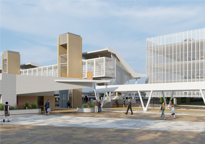
Beenleigh train station is a key transfer location between all-stops and express services on the Beenleigh and Gold Coast train lines.
Planning will be undertaken for the section of the road between Logandale Boulevard and Mount Cotton Road.
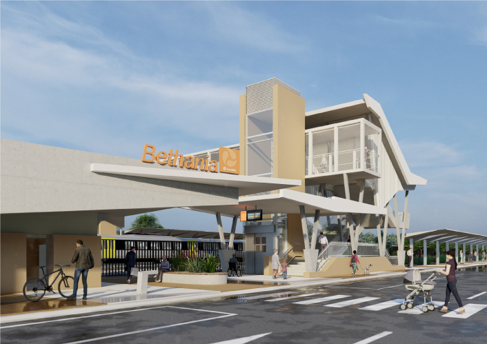
Bethania train station is being upgraded to improve accessibility, safety and customer experience.
The department is designing an upgraded link for bicycle riders and pedestrians between Kurilpa Bridge and Victoria Bridge on the Bicentennial Bikeway.

Planning is underway to improve flood immunity and safety on a section of Booral Road at Bunya Creek, including the Main Street intersection.
A study investigating transport issues and opportunities relating to movement to, from and within the Bribie Island and surrounding area to identify opportunities for further action.
Planning is underway to deliver more benefits to our customers by integrating Brisbane Metro into the Woolloongabba precinct and connecting Brisbane's busway network with Cross River Rail.
We are developing a rail corridor vision and a staged program of rail priorities to 2051 on the North Coast Line between Brisbane and Gympie North.
A business case is underway for a possible future project on Brisbane–Beenleigh Road between Loganlea Road and Waterford–Tamborine Road at Waterford.

The department is planning to upgrade the Bruce Highway from Anzac Avenue, North Lakes to Uhlmann Road, Burpengary.

The department is planning to upgrade the Bruce Highway from Buchanan Road, Morayfield to Caboolture-Bribie Island, Caboolture.

The Bruce Highway - Gateway Motorway to Dohles Rocks Road (Stage 1) project is part of integrated planning for the Gateway Motorway and Bruce Highway Upgrades in north Brisbane and the Moreton Bay Region.

The department is planning to upgrade the Bruce Highway from the Uhlmann Road, Burpengary to Buchanan Road, Morayfield.

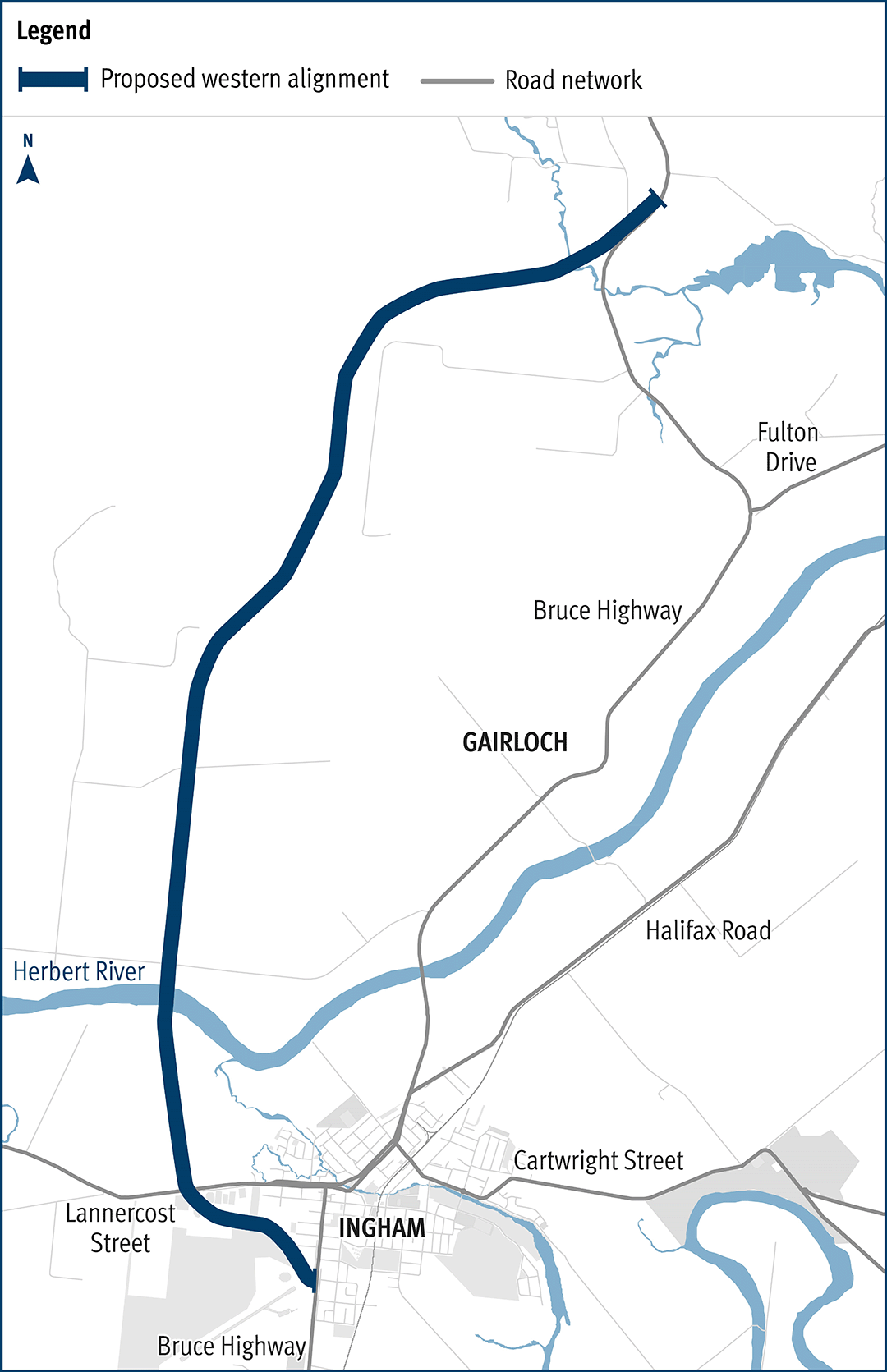
Planning has started to improve safety and reduce the time of closure due to flooding on a complex section of the Bruce Highway at the Gairloch floodway, approximately 6km north of Ingham.
The department is progressing a $9 million planning project to plan and protect a suitable road corridor for a future bypass of Innisfail, if required.
A planning study has been undertaken to investigate future upgrade requirements on the Bruce Highway between Deception Bay Road and Caboolture-Bribie Island Road.
We have completed early planning to determine future upgrade needs for the Bruce Highway between the Sunshine Motorway and Maroochydore Road. The planning identifies a long-term solution to meet future traffic growth, reduce traffic congestion, and improve safety and flood immunity.
The department has been actively working with the community to address the challenges associated with the Bruce Highway from South of Ingham to the Cardwell Range.
Planning for the Bruce Highway, Cairns Southern Access Corridor (Stage 5), Foster Road upgrade intersection project will assess and recommend options to upgrade this intersection.
The Bundaberg Integrated Transport Strategy is being jointly developed by the Department of Transport and Main Roads and Bundaberg Regional Council to develop an overarching framework that aims to integrate plans and policies, current and future, relating to the movement of people and services.
The department is finalising a business case for the construction of a new bridge to Bribie Island.
Cairns Transit Network is the first busway planning project of its kind in regional Queensland. It will improve public transport in Cairns by giving buses priority, either in separate bus lanes or on dedicated bus-only lanes (busways) which will be separated from general traffic.
By 2046, the Cairns local government area is expected to increase by approximately 59,000 residents. In addition to the substantial visitor numbers in the region, this significant residential growth will have an impact on the safety, efficiency and accessibility of the Cairns urban transport network.
Taking a holistic approach to the planning of this expected growth will ensure a sustainable, efficient and accessible transport network in the region.
Options to improve safety and reduce congestion are being investigated at the Caloundra Road, Kawana Way Link Road and Bells Creek Arterial Road intersection in Caloundra.
The department has started planning for an off-road cycle link along approximately 3.5km of Caloundra Road.

3 high priority sections of the Capricorn Highway between Emerald and Alpha have been widened.
Master planning is progressing on the Captain Cook Highway between Cairns CBD and Smithfield.

Works will involve pavement widening and sealing of various sections of the Carnarvon Highway between 85.16km and 87.44km east of St George.

The department is developing a masterplan for the Centenary Motorway corridor between Darra and Toowong to improve safety, travel-time and meet the increasing transport demands of the community.
Together with the Gold Coast City Council, we are working on the Central Gold Coast East-West Passenger Transport Study.
The department is upgrading Cleveland-Redland Bay Road, between Anita Street and Giles Road in Redland Bay.

Planning is underway for the future stages of the Coomera Connector – the remaining 29km between Loganholme and Coomera.

Planning has been undertaken for the upgrade of the intersections at Diamond and Elm Streets and Myall and Elm Streets at Cooroy.
The department is undertaking planning for the remaining sections of the Ipswich Motorway between Rocklea and Darra.

Planning has started for an interim upgrade of the Cunningham Highway and Ipswich–Rosewood Road intersection in Amberley.
Planning is underway to upgrade the Cunningham Highway.

Planning is underway to develop a long-term vision for the future of Brisbane-Woodford Road (known as Dayboro Road) between Gympie Road and Youngs Crossing Road.

A planning study is underway to upgrade and expand the northern side of the park 'n' ride at Dinmore station.
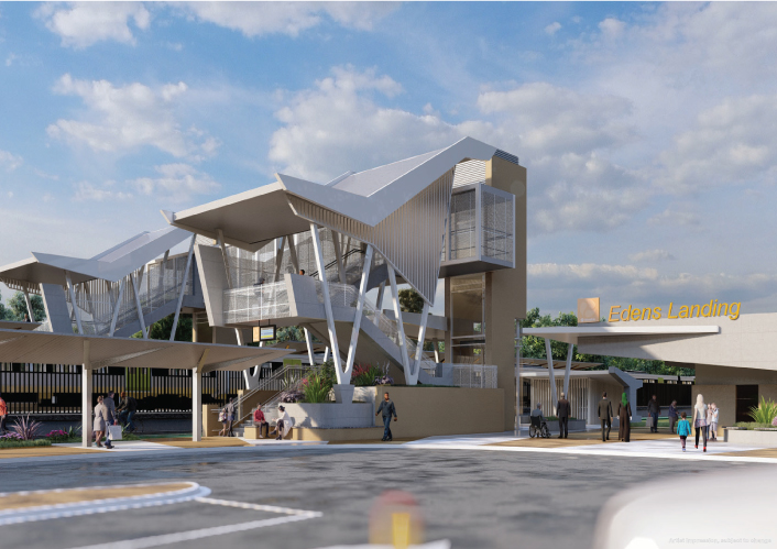
Edens Landing station is being upgraded to improve accessibility, safety and customer experience.
The department has delivered 9km of pavement strengthening and widening of the floodway along the Flinders Highway between Julia Creek and Cloncurry at Scrubby Creek.

The Gateway Motorway (Bracken Ridge to Pine River) project is part of integrated planning for the Gateway Motorway and Bruce Highway Upgrades in north Brisbane and the Moreton Bay Region.

This planning project aims to identify a new permanent alignment for Gatton–Clifton Road to bypass a 400m section that is affected and at-risk from a large and slow-moving landslip at Mount Whitestone.
We are continuing to protect and plan for the Gold Coast heavy rail corridor between Varsity Lakes and Gold Coast Airport.
Planning has started on the proposed Currumbin Creek Active Transport Bridge between Palm Beach and Currumbin.
The department is undertaking planning for future upgrades to the Gold Coast Highway at the intersection of Captain Cook Drive/Pine Ridge Road due to the high volume of traffic causing congestion and delays. The future upgrade aims to improve traffic flow and safety at the intersection
The proposed Gold Coast Light Rail Stage 4 is a world class public transport system for residents and visitors to the Gold Coast.
We are planning for a future upgrade of the Mudgeeraba Creek Causeway on Gold Coast–Springbrook Road, Austinville.
This project has trialled sustainable pavement systems and products to rehabilitate deteriorating sections of the Gore Highway.
The package of Gregory Developmental Road upgrades is delivering a stronger and wider surface, improving travelling conditions for motorists and upgraded a major culvert to improve flood resilience.
Around 67,000 vehicles travel each day between the northern suburbs and inner Brisbane, crossing Downfall Creek Bridge on Gympie Arterial Road at Chermside.
Planning is underway to upgrade Downfall Creek Bridge structures, some of which date back to 1927.The upgrade will improve the reliability of the transport network, safety for all users and traffic flow along this section of road, including the adjacent Gympie Arterial Road and Murphy Road intersection.
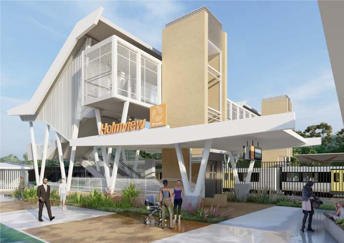
Holmview train station is being upgraded to improve accessibility, safety and customer experience.
Ipswich is a rapidly growing and dynamic local government area. New neighbourhoods are emerging and existing communities continue to expand and mature. People's travel behaviours and expectations around a wider range of travel choices and modes are changing.
We have started the next stage of planning for a future Ipswich to Springfield public transport corridor.
The department undertook community consultation in early 2021 on a proposed improvement for the Ipswich-Cunningham Highway Connection Road (Brisbane Road), Chermside Road and Glebe Road (East Ipswich Fiveways) intersection in East Ipswich. The proposed upgrade included changing Glebe Road into a cul-de-sac to improve safety and traffic flow.

Options are being investigated for a new motorway link (Kawana Motorway) between Parrearra and Meridan Plains. This new motorway will help cater for the growing population.
A study has been undertaken to investigate a bypass at Fig Tree Pocket using the existing preserved corridor.
The department has delivered 48km of new sealing along the Kennedy Developmental Road between The Lynd to Hughenden.

The Barron River bridge planning project aims to explore long-term, sustainable solutions for the bridge located near Kuranda.
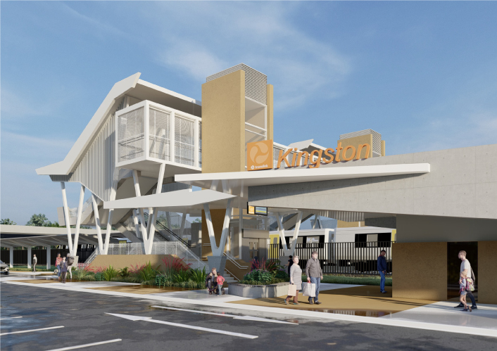
Kingston train station is being upgraded to improve accessibility, safety and customer experience for the community.
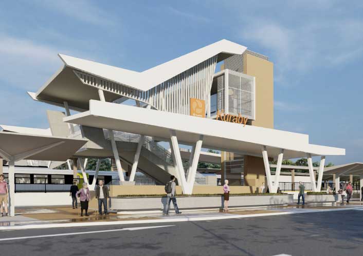
Kuraby station is being upgraded to improve accessibility, safety and customer experience for the community.
We have identified and preserved a new rail corridor between Landsborough and Nambour, which will replace the existing North Coast line through this section.
We are working with all levels of government to improve safety and accessibility at the Lindum Station and level crossing.
We are relocating Loganlea train station and the park 'n' ride closer to Logan Hospital.
We are looking into ways to improve services and replace the trains used for the long-distance network connecting many destinations across Queensland.
Mackay Port Access will provide a direct link for freight movements from the Mackay Port to the Mackay Ring Road, and west to the Bowen Basin coal fields via the Walkerston Bypass and Peak Downs Highway.
Planning is underway to identify potential future upgrades to Mackay – Bucasia Road to improve congestion, safety, and flooding impacts on this vital link to the Northern Beaches.

The Manly Boat Harbour is an integral part of the bayside’s social, cultural and economic landscape. We are currently undertaking a master planning process to help guide future activities at the boat harbour.

This project will progress planning for the southern section of the Mareeba Bypass and review the alignment of the northern section.

Planning will identify a preferred option for a future upgrade that improves efficiency, safety, and reliability for all road users. Active transport facilities will be among the key considerations.
The department is undertaking planning for the full length of Maroochydore–Noosa Road which runs from Ocean Street, Maroochydore to Emu Mountain Road, Peregian Springs.
Planning is underway for an upgrade of the Maryborough-Hervey Bay Road, Ibis Boulevard and Fairway Drive intersection.

Planning is underway to improve active transport infrastructure and safety along Moggill Road.

In 2021, an upgrade was proposed for the Kenmore roundabout at the intersection of Moggill Road and Brookfield Road in Kenmore. The upgrade proposed removing the roundabout and signalising the intersection, and also included provision for active transport users.
We are planning for a long-term solution to improve safety and accessibility for all users.

The department is undertaking a planning study for Mount Cotton Road, Redland Bay Road and Redland Sub-Arterial Road.
The department is undertaking planning to progressively upgrade the Beaudesert Road corridor, from the Logan Motorway towards Compton Road.

The planning projects investigated future infrastructure to improve safety and efficiency on the New England Highway, south of Toowoomba.
The department has a planning project underway to investigate safety improvements at Back Creek on the New England Highway south of Cooyar.
The Australian and Queensland governments have jointly funded planning to address current and emerging transport issues in the Bruce Highway corridor.
The Townsville City Centre to James Cook University bikeway planning project will establish a long-term vision to provide a fit-for-purpose, interconnected and safe bike route between the Townsville City Centre and the University Drive underpass in Annandale.
Planning is underway to improve safety, efficiency and reliability of Oakey-Pittsworth Road.

Planning is underway for the Pacific Motorway (M1) – Daisy Hill to Logan Motorway upgrade. This section of the M1 cannot accommodate current traffic volumes and, as a result, experiences frequent and prolonged periods of congestion and poor travel time reliability.
Planning and construction is underway for short and long-term upgrades of various interchanges on the Pacific Motorway (M1)
We are preserving the Park Ridge Connector, a future transport corridor to connect communities planned at Park Ridge, Flagstone and Yarrabilba to services and employment.
An upgrade is being delivered to a 1.5km section of Proserpine-Shute Harbour Road in Cannonvale.
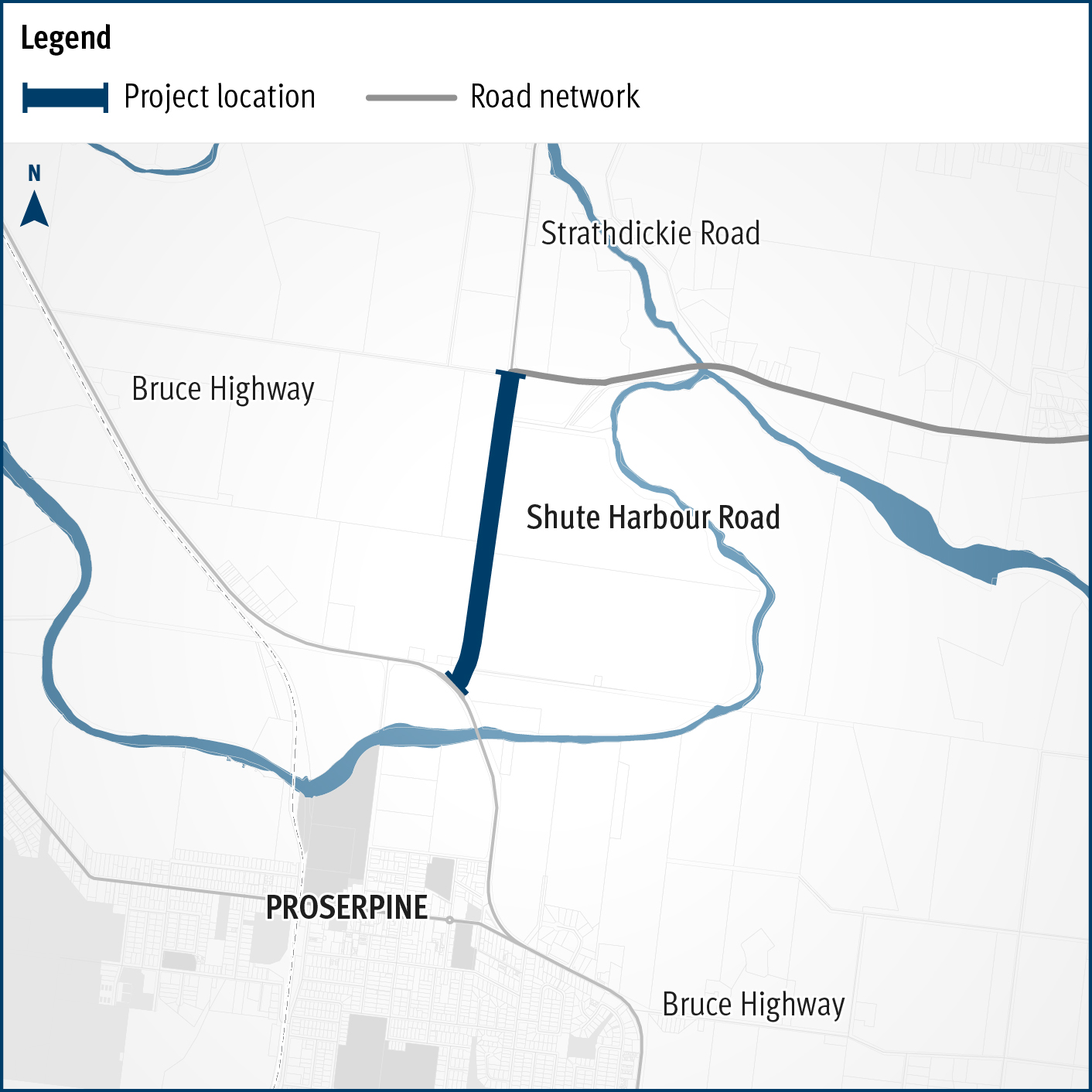
A flood immunity upgrade will be delivered to a 1.5km section of Proserpine – Shute Harbour Road at Hamilton Plains between the Bruce Highway turn-off and Strathdickie Road.
The department is undertaking planning for Mount Cotton Road, Redland Bay Road and the Redland Sub-Arterial Road.

The department is undertaking planning for Mount Cotton Road, Redland Bay Road and the Redland Sub-Arterial Road.
The Queensland Government has purchased the historic Rockhampton railyards. Planning for rejuvenation of the railyards has commenced, and remediation activities are now underway.

Rockhampton-Yeppoon Road is a regional road linking the Capricorn Coast, including tourist locations, such as Great Keppel Island to Rockhampton and beyond.
We are planning for a proposed passenger rail line between Salisbury and Beaudesert.
Stage 1 of the Salisbury train station park ‘n’ ride is now complete.

Initial community consultation was undertaken on proposed safety and traffic improvement works at key intersections along Samford Road, at Glen Holm Street and Osborne Road.

Scarborough Boat Harbour is a vibrant part of the Redcliffe Peninsula community. We are currently undertaking a master planning process to help guide future activities at the boat harbour.
A study is underway to identify and prioritise road network connectivity and safety improvements to increase road capacity within the growing southern Sunshine Coast area.
The Stafford Road and South Pine Road Intersection Upgrade planning study delivered a 2-staged concept plan to improve traffic flow and increase capacity. The plan includes safety improvements at Sizer and McIlwraith streets, as well as pedestrian and bike riding upgrades in the area.
Last updated: 30 May 2024