
Mackay Ring Road
An improved link has been delivered from the south to the northern suburbs reducing traffic through Mackay.
Construction
An improved link has been delivered from the south to the northern suburbs reducing traffic through Mackay.
Construction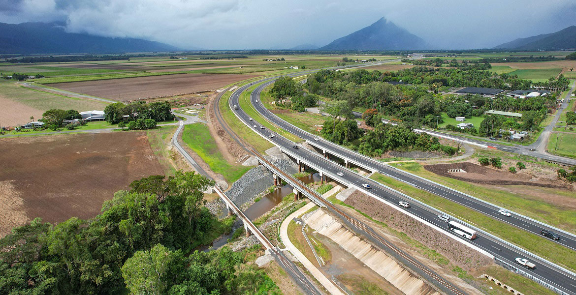
A total transport solution has been delivered to provide long-term improvements to traffic flow and road safety through reducing congestion, highway travel time and improving road access.
Completed
The department is undertaking integrated planning for the Gateway Motorway and Bruce Highway Upgrades in north Brisbane and the Moreton Bay Region.
The Bruce Highway Upgrade Program is the largest road infrastructure program in Queensland, aimed at enhancing safety, flood resilience, and capacity along the Bruce Highway between Brisbane and Cairns. It was initiated on 1 July 2013, with a 10-year commitment valued at $8.5 billion, jointly funded by the Australian and Queensland Governments.
Over the years, the program received additional funding commitments. In May 2018, the Australian Government committed an additional $3.3 billion (based on 80:20 funding arrangements) to its existing $6.7 billion commitment. The State's annual Bruce Highway funding commitment will increase to $250 million per annum from 2027–28 onwards, on top of the additional $1.8 billion the Queensland Government has already provided.
In 2022, a jointly funded boost of $883 million was introduced specifically to target upgrades to various sections of the Bruce Highway, including areas between Gladstone and Rockhampton, between Mackay and Proserpine, north of Townsville, and the Tiaro Bypass.
To ensure proper management and oversight, the Queensland Government established the Bruce Highway Trust Advisory Council. This council was responsible for developing a 15-year Vision and three 5-year rolling Action Plans, along with the Safer Bruce 2030 Action Plan, on this nationally significant link to:
The Bruce Highway Trust Advisory Council was supported by a Technical Working Group established within the department comprising technical and subject-matter experts.
The Bruce Highway Upgrade Program is on track with the delivery of:
The Bruce Highway is a crucial transportation route in Queensland, serving as the major north-south freight and commuter corridor, connecting various coastal population centres from Brisbane to Cairns over a total length of 1,673km. It plays a vital role in the National Land Transport Network linking west-east freight networks, connecting resource sectors, inland agriculture production areas, and coastal ports, while also serving as a major tourism route.
The Bruce Highway Upgrade focuses on the 3 priority areas during its 15-year course:
As with any major construction program, there might be delays that could affect travel. Therefore, it is advised to plan ahead and check for up-to-date details on QLDTraffic to help you plan your journey.

The department is undertaking the rehabilitation and maintenance program for the Burdekin River Bridge to preserve the structural integrity of the bridge. The ongoing program will ensure a safe and durable crossing is maintained for the long-term use of vehicles, heavy transport operators, rail operations, bicycle riders and pedestrians.

The Barcaldine-Aramac Road is undergoing upgrades with an additional 5km being widened to improve travel conditions.
The Beams Road rail level crossing project will reduce congestion and address safety concerns. The current rail level crossing on Beams Road will be replaced with an overpass to separate road and rail.
Improvements to approximately 14km of the Brisbane Valley Highway will reduce the rate and severity of crashes and improve traffic efficiency.
We are developing a rail corridor vision and a staged program of rail priorities to 2051 on the North Coast Line between Brisbane and Gympie North.
Safety on the Bruce Highway at Inkerman will be improved through the installation of new northbound overtaking opportunity and upgrades to the Mount Inkerman Road intersection.

The department is planning to upgrade the Bruce Highway from Anzac Avenue, North Lakes to Uhlmann Road, Burpengary.

The department is planning to upgrade the Bruce Highway from Buchanan Road, Morayfield to Caboolture-Bribie Island, Caboolture.
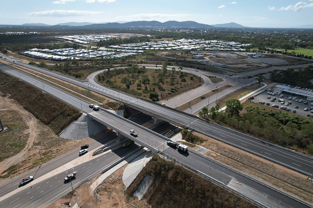
Major construction was completed for the Bruce Highway Upgrade — Caboolture-Bribie Island Road to Steve Irwin Way project in April 2024. This project widened the 11km stretch of the Bruce Highway from 4 to 6 lanes between Caboolture-Bribie Island Road and Steve Irwin Way (Exit 163). This also included upgrading creek crossings to improve flood immunity at Lagoon, King Johns, Six Mile, Un-named and Beerburrum Creeks.

The department is planning to upgrade the Bruce Highway from the Uhlmann Road, Burpengary to Buchanan Road, Morayfield.

The department is delivering staged upgrades to manage increasing traffic demands on this section of the Bruce Highway. Stage 1 includes extended north-facing ramps from Dohles Rocks Road to Anzac Avenue.

The $1.162 billion Section D: Woondum to Curra project is a new 26km, 4-lane divided highway between the existing Bruce Highway interchange at Woondum, south of Gympie and Curra.
Planning is complete and the detailed design stage has commenced for a new four-lane section of the Bruce Highway to the east of Tiaro. The project will increase the flood immunity, safety and efficiency of the Bruce Highway and future-proof the road to cater for growing traffic volumes. It will also remove a significant number of heavy vehicles from the Tiaro township, improving safety and liveability for residents.

Planning has started to improve safety and reduce the time of closure due to flooding on a complex section of the Bruce Highway at the Gairloch floodway, approximately 6km north of Ingham.
The department is progressing a $9 million planning project to plan and protect a suitable road corridor for a future bypass of Innisfail, if required.
The department is progressing a project to upgrade the intersection of the Bruce Highway and Munro Street at Babinda.
Upgrades to improve flood immunity at Jumper Creek, between Mackay and Proserpine are now complete.
Construction has started at the Knobels Road and Nebia Coningsby Road intersection to improve safety and enhance visibility.
This project will provide Intelligent Transport System infrastructure at various locations along the Bruce Highway between Pine River and Cairns.
Safety upgrades have been completed to almost 20km of the Bruce Highway from Proserpine to Bowen, as part of the Bruce Highway Upgrade Program.
Bruce Highway works, between Townsville and Ingham, are underway to improve safety and upgrade a rest area.

Bruce Highway upgrades between Leichhardt Creek and Cassowary Creek (about 42km north of Townsville).
The department has delivered a planning project to investigate and prioritise upgrades to the Bruce Highway between the Pine River and Caloundra Road.
A planning study has been undertaken to investigate future upgrade requirements on the Bruce Highway between Deception Bay Road and Caboolture-Bribie Island Road.
We have completed early planning to determine future upgrade needs for the Bruce Highway between the Sunshine Motorway and Maroochydore Road. The planning identifies a long-term solution to meet future traffic growth, reduce traffic congestion, and improve safety and flood immunity.
The Bruce Highway - Pine River to Caloundra Road Smart Motorways (Stage 2) project will deliver additional Smart Motorways technology along a 60km section of the Bruce Highway between the Pine River and Caloundra Road.
A total transport solution has been delivered to provide long-term improvements to traffic flow and road safety through reducing congestion, highway travel time and improving road access.
Planning for the Bruce Highway, Cairns Southern Access Corridor (Stage 5), Foster Road upgrade intersection project will assess and recommend options to upgrade this intersection.
This project involves a 62km realignment and upgrade of the Bruce Highway to 4 lanes between Cooroy and Curra and is among Queensland's highest priority road projects.
Construction is underway to implement safety improvements for Caboolture – Beachmere Road (locally known as Beachmere Road) and enhance overall driving conditions.
The Cairns Bruce Highway Upgrade master plan was released in 2010. It was the result of a planning study that investigated long term, multi-modal transport planning options to address the impacts of urban growth, congestion and traffic accidents.

The Department is reinvesting project savings to deliver a new off-road cycleway next to the Bruce Highway, consistent with the Cairns Bruce Highway Upgrade Masterplan. The project will deliver a safe off-road facility for bicycle riders of all abilities, including school children and the active transport community. The new cycleway also delivers a direct and continuous route with limited intersections to encourage bicycle riders to use the off-road facility.
The Cape York Region Package Stage 2 is a program of works to deliver infrastructure upgrades on the Cape York Peninsula between 2019-2020 and 2023-2024.
The Capricorn Highway is a key freight route and supports a wide range of industries including agriculture, resources and mining. It plays an important role in connecting Rockhampton with central and western communities in Queensland.

The Carnarvon Highway (Injune - Rolleston), Dawson River bridge upgrade project will improve safety and network efficiencies by realigning the approaches and widening the existing structure.

Works will involve pavement widening and sealing of various sections of the Carnarvon Highway between 85.16km and 87.44km east of St George.
The department is improving the flood immunity and resilience of the Castlereagh Highway near Dirranbandi.

The Centenary Bridge Upgrade in Jindalee will increase capacity and improve safety on the Centenary Bridge by building a new 3-lane northbound bridge and rehabilitating the existing bridges to 3 lanes southbound including upgrades to active transport facilities.
The department is undertaking a $110 million package of works to upgrade Cleveland-Redland Bay Road.

The Stage 1 section of the Coomera Connector between Coomera and Nerang has been identified as the priority section to be built first.
Coomera Connector (Stage 1) is around 16km and will be delivered in 3 construction packages. Stage 1 North, which is currently under construction, is the 4km section from Shipper Drive to Helensvale Road.

The department is committed to restoring and repairing the damaged section of the Cunningham Highway at Cunninghams Gap. This 2km stretch, leading up to the Allan Cunningham monument, suffered significant road damage during the bushfires in 2019.
Construction and design works are underway for upgrades at various locations as part of a program of works to improve the D'Aguilar Highway between Yarraman and Kingaroy.
Works involve widening to 8m and sealing a 4.7km section of the Diamantina Developmental Road (Quilpie – Windorah).

Safety upgrades will be carried out at various locations along Douglas – Garbutt Road.

The Eastern Transitway will provide bus customers in Brisbane's east with a safer and more efficient public transport network. The project will deliver targeted bus priority measures to improve safety, reliability, and capacity along Old Cleveland Road from Coorparoo to Carindale.
Construction is underway for safety improvements on Eumundi—Noosa Road for all road users, including bike riders.
The department is improving the flood immunity and resilience of the state-controlled road network at 27 priority sites.
Traffic flow and safety are being improved on Gatton-Helidon Road.
This project will improve safety at various locations along Glass House Mountains Road (locally known as Steve Irwin Way) between Glass House Mountains and Beerwah.

Gold Coast Light Rail is a world class public transport system for residents and visitors to the Gold Coast.
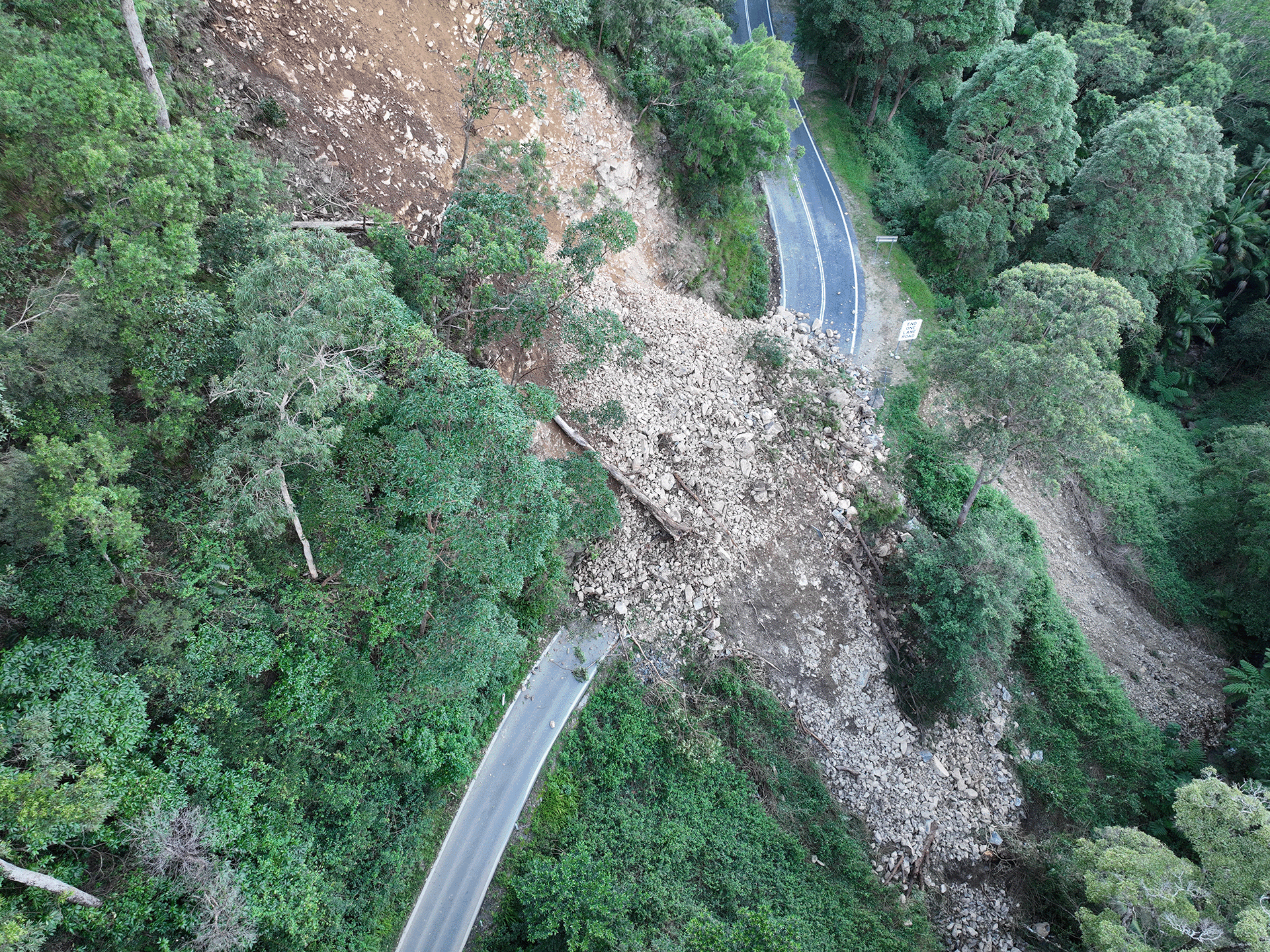
Gold Coast-Springbrook sustained a significant number of landslips, rock falls and tree falls over a 10-kilometre section during extreme rainfall and flooding events from 22 February to 20 May 2022.
A new bridge at Wyaga Creek crossing on the Gore Highway will improve flood immunity, safety and efficiency on one of Queensland's most important transport links.
This project has trialled sustainable pavement systems and products to rehabilitate deteriorating sections of the Gore Highway.
The package of Gregory Developmental Road upgrades is delivering a stronger and wider surface, improving travelling conditions for motorists and upgraded a major culvert to improve flood resilience.
The Gulf Developmental Road is the principal freight and tourism route connecting Carpentaria Shire via the Kennedy Highway, with the Bruce Highway coastal link. The road is sealed, however there are 19 sections spread over 47kms that are only single lane.
The department is replacing a section of noise barriers on the western side of Gympie Arterial Road, north of Strathpine Road in Bald Hills.
The department will improve safety on a 40km stretch of the Isis Highway from Airport Drive to the Bruce Highway.
Design and construction to rehabilitate and widen priority sections of Kin Kin Road (locally known as Pomona Kin Kin Road) is underway. This will improve safety, reduce maintenance costs and improve ride quality on Kin Kin Road.
We've completed extensive investigations on our operational management of Kin Kin Road in response to community concerns around heavy vehicle traffic.
Design is underway for a bikeway on Olsen Avenue between the Gold Coast Highway and Napper Road.

The department is working on multiple locations along Lamington National Park Road which require pavement rehabilitation and permanent reconstruction work following record rainfall across south east Queensland since December 2020.
The department has been investigating options to reduce traffic congestion and improve safety and freight access for the Linkfield Road Overpass in Bald Hills.
Mackay Port Access will provide a direct link for freight movements from the Mackay Port to the Mackay Ring Road, and west to the Bowen Basin coal fields via the Walkerston Bypass and Peak Downs Highway.
An improved link has been delivered from the south to the northern suburbs reducing traffic through Mackay.
Construction has started on widening and sealing 2 sections of Maleny-Kenilworth Road in the Conondale and Cambroon areas to provide a sealed lane and shoulder in each direction.
Construction is underway for safety improvements to the intersections of Bradman Avenue/Diura Street and Bradman Avenue/Denna Street, Maroochydore.
The department is progressively upgrading and sealing the gravel sections of Monto - Mount Perry Road to improve road user safety and comfort, and reduce future maintenance requirements.
This project is focused on improving safety along various sections of this 36km road where there is a high crash history.

Safety upgrades will be carried out at various locations along North Ward Road.

The department is delivering targeted bus priority from Kedron to Chermside, improving the safety and capacity of this important link in Brisbane's northern public transport network.

A rail facility is being constructed on a 66ha site in the Gold Coast region.

The Pacific Motorway (M1) between Watland Street and Sports Drive is being upgraded as part of a rolling program of upgrades between the Gateway and Logan Motorways.

The M1 between Burleigh and Palm Beach (Package B) is being upgraded as part of the Varsity Lakes to Tugun (VL2T) upgrade. Package B will include significant environmental features through this section of the upgrade.

The Pacific Motorway (M1) is being upgraded between Palm Beach and Tugun (Package C) as part of the Varsity Lakes to Tugun (VL2T) upgrade.

The $1.5 billion Pacific Motorway Varsity Lakes to Tugun (VL2T) project is being delivered to upgrade 10km of the M1 and is being constructing in packages to ensure faster delivery and best value for money.
Work is being undertaken on the Pacific Motorway, Eight Mile Plains to Daisy Hill Upgrade, to improve 8kms of the Pacific Motorway (M1) between the Gateway Motorway and Watland Street.

As part of a rolling program of Pacific Motorway (M1) upgrades, detailed design for the Rochedale bus station and park 'n' ride is now complete.
The Exit 49 interchange upgrade will deliver significant improvements in safety and traffic flow efficiency by keeping traffic moving through the improved interchange and thereby reducing queuing.
We own and maintain over 430 pieces of marine infrastructure valued at about $153 million. These include assets such as state boat harbours, boat ramps, jetties, pontoons, floating walkways, channels, and breakwaters/rock groynes.
The department will improve all weather access, travel reliability and safety along the Richmond – Winton Road by widening and strengthening this section of the road.
The Rockhampton Ring Road is a long-term, visionary project for the Bruce Highway. It will unlock future economic growth and deliver significant benefits including improved flood resilience, freight efficiencies and road safety, and reduced travel times.

Rockhampton-Yeppoon Road is a regional road linking the Capricorn Coast, including tourist locations, such as Great Keppel Island to Rockhampton and beyond.
Construction is underway for a project to improve safety along a 1.5-km section of Samford Road, between Lomandra Access Road picnic area and Camp Mountain Road, and at the Camp Mountain Road intersection.

Reconstruction works are underway across the South East Region, including the Gold Coast and Scenic Rim, to repair storm damaged roads.
We are working in partnership with Queensland Rail to develop a number of new purpose-built, modern train stabling facilities across the rail network critical to accommodate new trains delivered by the New Generation Rollingstock (NGR) project.

Repairs are underway across southern Queensland after extensive and severe damage to the state-controlled road network was caused by multiple heavy rainfall and flooding events in 2022.
Construction is underway for safety improvements on Strathpine-Samford Road between Eatons Hill and Samford Valley.
The department values the protection of native fauna and supports koala protection treatments and initiatives to help mitigate koala-vehicle collisions.

A new facility is being constructed in the Maryborough region, to manufacture the Queensland Train Manufacturing Program fleet.
Work is underway on flood immunity and intersection upgrades along sections of Torbanlea – Pialba Road between Beelbi Creek and Takura.
The Townsville Connection Road is being upgraded to dual lanes between University Road and Bowen Road Bridge. The project includes upgrades at 3 intersections: Gartrell Drive, Mervyn Crossman Drive/Fairfield Waters Drive and Kokoda Street.
The Townsville Ring Road Stage 5 project, a landmark initiative that has brought about substantial improvements in road safety, traffic flow and travel time predictability for both freight and passenger vehicles along the Bruce Highway in Townsville, has been completed.
The Varsity Lakes station park 'n' ride upgrade is delivering close to 350 parking spaces.

The Veloway 1 is a dedicated cycleway running between Lower River Terrace, South Brisbane and Underwood. The 20km cycleway provides a safe and efficient route for bike riders.

The Walkerston Bypass will deliver a new 2-lane rural highway to connect Peak Downs Highway west of Walkerston to the Mackay Ring Road near Paget.
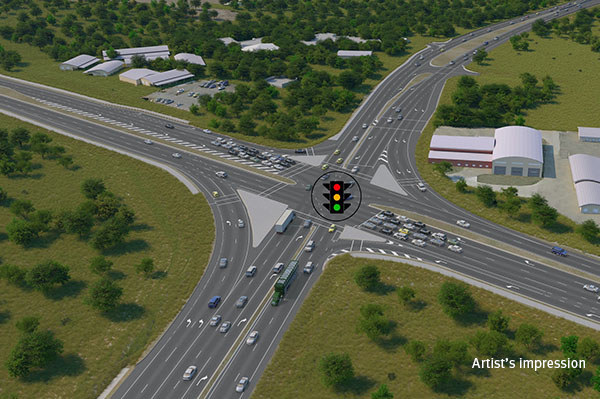
Construction is underway to replace the roundabout with a signalised intersection.
We are constructing a new recreational boat launching facility at Yorkeys Knob.
Last updated: 2 July 2024