Showing results 41-50 of 113

Sort results
Sort results
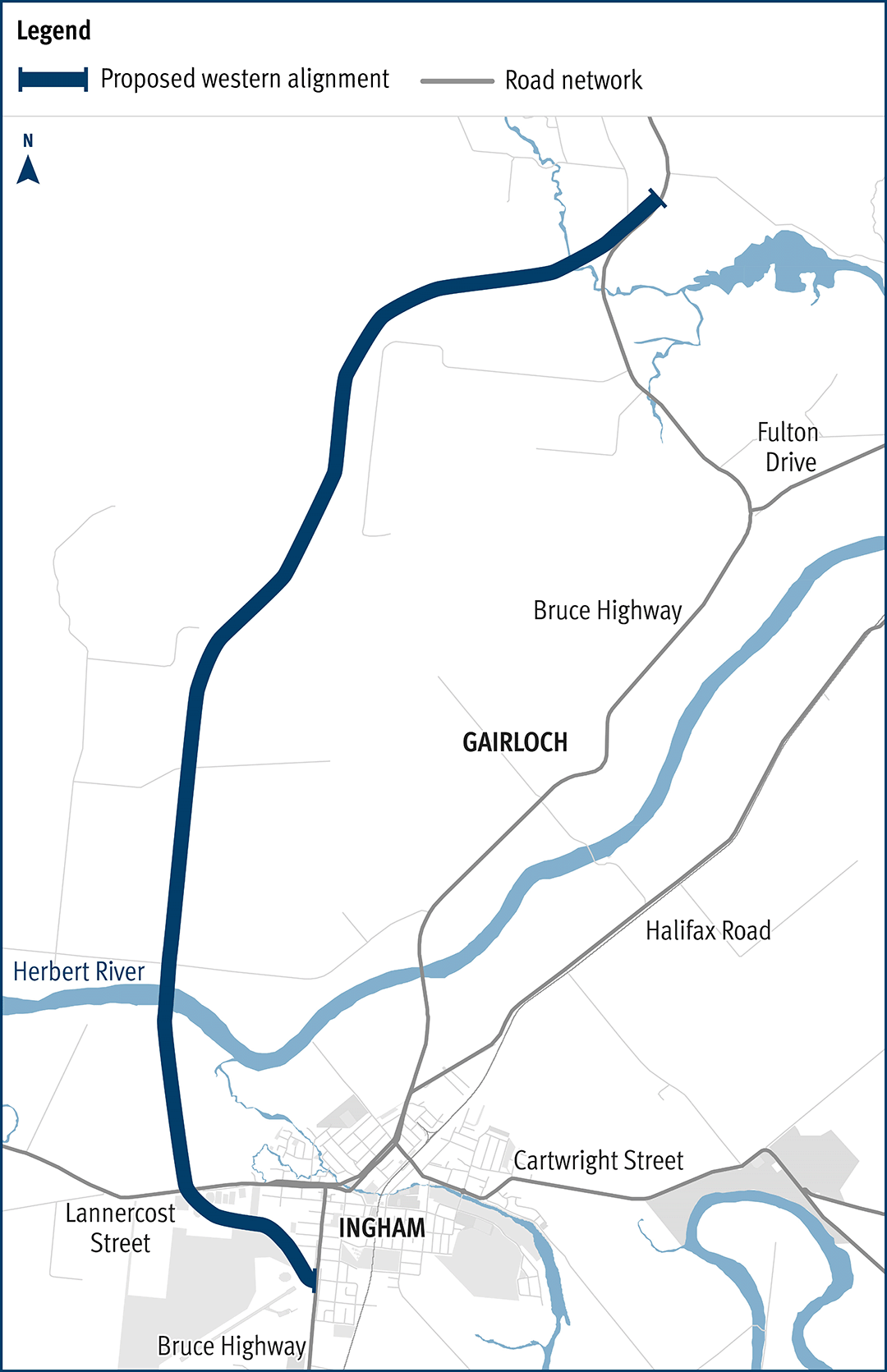
  1. Bruce Highway, (Ingham – Innisfail) Ingham to Cardwell Range Deviation, plan and preserve corridor

    The department has been actively working with the community to address the challenges associated with the Bruce Highway from South of Ingham to the Cardwell Range...

    The map shows the locality of the existing Bruce Highway, from south of Ingham, north through the Gairloch floodway and up to the Cardwell Range. Cardwell is northeast of the map. A solid dark blue line west of the Bruce Highway indicates the current proposed Ingham to Cardwell deviation project corridor. This is known as the Western 2A Deviation, which has been gazetted as future state-controlled road. The local road network, including Halifax Road and Lannercost Street are also highlighted on the map.
  2. Caboolture–Bribie Island Road, Bribie Island bridge, planning

    We are undertaking a business case for a new bridge to Bribie Island that will improve safety and reliability for all road users...

    Image: Artist’s impression of the proposed concept design for a new bridge with 2 eastbound traffic lanes and active transport located north of the existing bridge with 2 westbound traffic lanes on the existing bridge.
  3. Warrego Highway Upgrade Program

    The Warrego Highway Upgrade Program extends from Ipswich to Charleville and started in 2013. The program is focussed on improving freight productivity, efficiency, resilience and road safety...

    No image supplied
  4. Veloway 1: Lower River Terrace Velobridge

    The Veloway 1 (V1) is a dedicated bikeway designed to connect people riding bikes between Lower River Terrace, South Brisbane and Eight Mile Plains, adjacent to the Pacific Motorway...

  5. Beenleigh Connection Road (Logan Street) and City Road, intersection upgrade

    Planning is underway for a potential future project to upgrade the intersection at Beenleigh Connection Road (Logan Street) and City Road, in Beenleigh...

    No image supplied
  6. Cunningham Highway (Ipswich–Warwick) and Ipswich-Rosewood Road intersection, business case

    We have started planning for an interim upgrade of the Cunningham Highway and Ipswich–Rosewood Road intersection in Amberley...

    Thumbnail image of map showing location of upgrade section for the Cunningham Highway and Ipswich–Rosewood Road intersection in Amberley.
  7. Mareeba – Dimbulah Road, Mareeba Heavy Vehicle Bypass, planning

    This project will complete planning for the southern section of the Mareeba Bypass and review the alignment of the northern section...

    Vehicles travelling along Mareeba–Dimbulah Road locally known as Byrnes Street
  8. Bruce Highway, Cairns Southern Access Corridor (Stage 5), Foster Road upgrade intersection

    Planning for the Bruce Highway, Cairns Southern Access Corridor, (Stage 5) Foster Road upgrade intersection project will assess and recommend options to upgrade this intersection...

    No image supplied
  9. Oakey-Pittsworth Road, various locations, business case

    Planning is underway to increase safety, efficiency and reliability of Oakey-Pittsworth Road...

    No image supplied
  10. Booral Road, Bunya Creek floodway and Main Street intersection upgrade, planning

    Planning is underway to improve flood immunity and safety on a section of Booral Road at Bunya Creek, including the Main Street intersection...

    Alternative text: The map shows the locality of the proposed Booral Road, Bunya Creek floodway and Main Street intersection upgrade. Nikenbah is located to the north and Hervey Bay to the north-east. Bunya Creek is located just north west of the proposed project location. A solid dark blue line indicates the project extent, which encompasses the Booral Road and Main Street intersection as well as the Bunya Creek floodway along Booral Road, which is located just west of the intersection. The local road network, including Woods Road and Vanderwolfe Road are also highlighted on the map.